
Résumés
Abstract
While the written terms of the Columbia River Treaty appear to justify the often-heard claim that it is all about hydropower and flood control, a full account of its history reveals its critical importance to US agriculture and close relationship to early phases of colonization and development in the Upper Columbia River Basin. In this paper I argue that the Treaty is best understood as the third phase in the last large-scale government-sponsored settler colonialism project in North America, a project that began with the construction of the Grand Coulee Dam in the 1930s. I further argue that the dominant narrative that informs current efforts by Canada and the US to revise the treaty does not fully recognize the settler colonial structure of the original treaty or its critical impact on both Indigenous and settler food systems throughout the basin. I begin with a description of the history of the treaty, in order to demonstrate its continuity with earlier phases of settler colonialism, then focus on its impact on food systems. I conclude with an assessment of the ongoing Canada/US treaty review and renegotiation process that began in 2011 with suggestions for how the process could be brought into better alignment with the United Nations Declaration on the Rights of Indigenous Peoples and the Calls to Action of the Truth and Reconciliation Commission of Canada.
Keywords:
- Columbia River Treaty,
- Columbia Basin Project,
- settler colonialism,
- irrigation,
- food systems,
- food sovereignty,
- decolonization,
- reconciliation
Résumé
Alors que les termes écrits du Traité du fleuve Columbia semblent justifier l’affirmation souvent entendue selon laquelle il ne s’agit que d’énergie hydroélectrique et de contrôle des inondations, un compte rendu complet de son histoire révèle son importance cruciale pour l’agriculture américaine et sa relation étroite avec les premières phases de colonisation et de développement dans le bassin supérieur du fleuve Columbia. Dans cet article, je soutiens que le traité est mieux compris comme la troisième phase du dernier projet de colonisation à grande échelle soutenu par le gouvernement en Amérique du Nord, un projet qui a commencé avec la construction du barrage de Grand Coulée dans les années 1930. Je soutiens, par ailleurs, que le récit dominant qui sous-tend les efforts actuels du Canada et des États-Unis pour réviser le traité ne reconnaît pas pleinement la structure coloniale du Traité original, ni son impact critique sur les systèmes alimentaires des autochtones et des colons dans l’ensemble du bassin. Je commence par décrire l’histoire du Traité, afin de démontrer sa continuité avec les phases antérieures du colonialisme de peuplement, puis je me concentre sur son impact sur les systèmes alimentaires. Je termine par une évaluation du processus de révision et de renégociation du traité entre le Canada et les États-Unis, qui a débuté en 2011, et par des suggestions sur la manière dont le processus pourrait être mieux aligné sur la Déclaration des Nations Unies sur les droits des Peuples autochtones et sur les appels à l’action de la Commission de Vérité et de Réconciliation du Canada.
Mots-clés :
- Traité du fleuve Columbia,
- projet du Bassin Columbia,
- colonie,
- irrigation,
- systèmes alimentaires,
- souveraineté alimentaire,
- décolonisation,
- réconciliation
Corps de l’article
Introduction
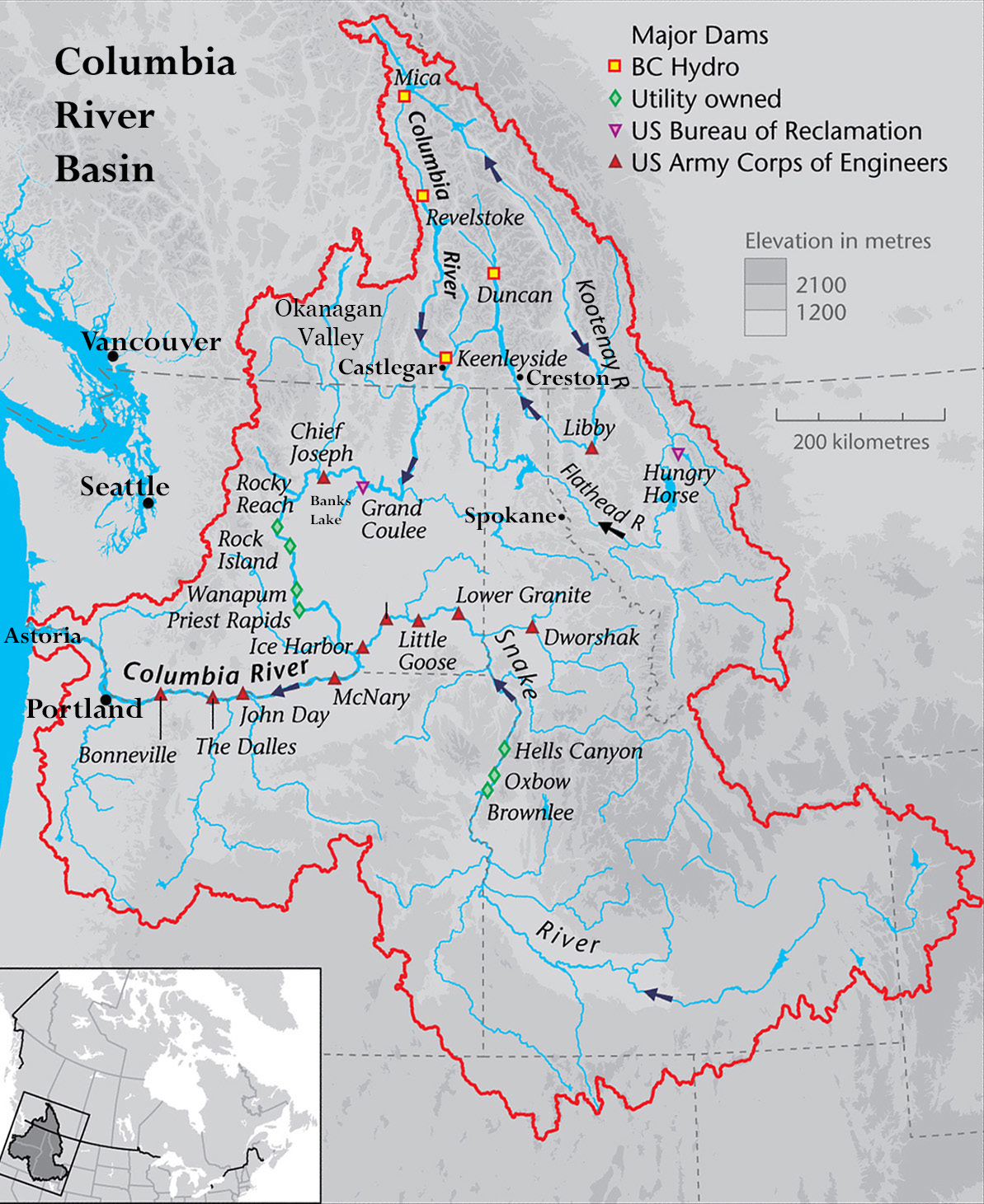
By the time the Columbia River Treaty (CRT) between Canada and the United States was ratified in 1964, there were already 10 large hydroelectric dams on the mainstem Columbia River in the US. The treaty extended this “capture” of the river (Pearkes 2016) to Canada, requiring the construction of two more mainstem dams in British Columbia, at Mica Creek and Castlegar, and two additional dams on Columbia tributaries, one on the Duncan River, north of Nelson, BC, and one in the US, in Montana, on the Kootenay River (see Figure 1). The stated purpose of the dams, as outlined in the treaty preamble and supporting documents, was to increase water storage capacity on the Upper Columbia above the Grand Coulee Dam during the spring freshet, to prevent flooding and, through a timely release of water throughout the remainder of the year, to increase the hydropower output of the Grand Coulee Dam and other power generators further downstream in the US (Canada and the United States of America 1964). But Article 13 of the treaty and Articles 6 and 10 of the attached “Annex to Exchange of Notes” include brief, less prominent clauses affirming that the US can divert as much Canadian storage water as it likes for “consumptive” uses of various kinds including irrigation (9-10, 22, 23). It is surprising that these clauses have received so little attention during the treaty review and renegotiation process underway since 2011, given the critical importance of Canadian storage water to US agriculture in the Upper Columbia (Holm 1994; Wagner and Taylor 2019) and the fact that its importance is likely to increase dramatically as climate change impacts intensify over the next several decades (Cohen et al. 2000; Payne et al. 2004; Rajagopalan et al. 2018).
Figure 1
Columbia River Basin Dams
The hidden nature of the irrigation clauses is also surprising given the history of the CRT project. The first documented proposal for a coordinated US-Canada approach to dam construction on the Columbia occurred in 1932, just as construction of the Grand Coulee Dam was about to begin (Dietrich 1995, 263). The first proposals for the Grand Coulee, in turn, date back much further, to the 1890s (Dietrich 1995, 258), and were always framed in terms of the need for irrigation water to unlock the agricultural potential of the arid west. Hydropower was initially a secondary consideration, though by the 1930s, by which time hydroelectric dams had become icons of modernity and progress (Haiven 2013, 215), development proposals for the Columbia recognized that electricity had become as essential to western settlement as irrigation. Construction of the Grand Coulee Dam would accomplish both goals in equal measure and, according to one promoter, would help realize “Thomas Jefferson’s dream of a great, free and independent empire on the banks of the Columbia” (Dietrich 1995, 43). Development of the Columbia, it was imagined, “would remake the Pacific Northwest, the final frontier in the Lower Forty-eight states, to conform to the most idealistic visions of the mid-twentieth century” (Dietrich 1995, 42).
In the pages that follow, I first describe the methodology that informs this paper and then focus on the history of the three-stage process that culminated in the CRT, emphasizing the importance of the treaty to long-term settler colonial aspirations on both sides of the international border. I then discuss the impact of the treaty on regional and global food security and food sovereignty issues. I conclude with a discussion of ongoing treaty negotiations between Canada and the US and propose a new approach for transboundary water governance in the Upper Columbia that is aligned with the United Nations Declaration on the Rights of Indigenous Peoples (UNDRIP), the calls to action of the Truth and Reconciliation Commission of Canada, and Indigenous critiques of recent decolonization and reconciliation moves within mainstream settler culture.
Methodology
This paper is intended as one in a series of publications describing an ongoing, long-term study of the Columbia River Basin and the Columbia River Treaty. The larger project is fundamentally ethnographic in design but, in this paper, I rely mainly on historical data and discursive analysis to reframe and retheorize what it is we are actually doing under the name of treaty revision. The long-term study began in 2005 with an ethnographic and historical study of water and agriculture in the Okanagan Valley of British Columbia, the unceded and traditional territory of the Syilx People (Wagner 2008). It continued from 2012 to 2014 in the form of an SSHRC-funded pilot study of water governance in the Columbia River Basin as a whole (Wagner and Taylor 2019), and from 2014 to 2022 through my engagement as a resident “insider” at numerous public events and conferences in multiple settings throughout the Upper Columbia Basin in British Columbia and Washington State.
I claim insider status in the Okanagan by virtue of having lived here for nearly 30 years, beginning in the 1970s. My two children were born here as were my daughter’s two children, making us now a three-generation settler family in the valley. Over the years I have also come to consider myself a member of what Joanne Taylor and I have described as the “Columbia Basin Nation” (2019), a term we use to describe an emergent social movement that has articulated a very different vision for the basin than that which informs the positions of our two countries’ negotiating teams.
My research approach in the Columbia Basin is ethnographic in the standard sense of that term, referring to reliance on interviews and lived experience as a participant-observer in the research setting, but it is also informed by the concept of “river ethnography” as I and a group of colleagues working in Oceania use that term (Wagner et al. 2018). We use it to describe a new genre of research and writing in which rivers are understood to be actors within cultural as well as ecological systems and therefore constitute research subjects in their own right.
Selective memory plays a prominent role, I discovered, in the way human/river relations are constructed in Kamiali, Papua New Guinea, and I find this to be the case in the Columbia River Basin as well. The dominant narrative informing current Columbia River Treaty negotiations forgets the importance of settler colonial agriculture to the original treaty, remembering only hydropower and flood control. This form of selective memory obscures the relationship of the treaty to food systems and the cultural values that sustain them, and creates serious challenges for the negotiators tasked with developing a new vision for the treaty.
Memory and Forgetting in Columbia River Basin Settler Culture
Stage One: The Grand Coulee Dam
The vision of the Columbia River Basin in the US as a region with massive potential for agricultural settlement was born as early as 1892 when one of the first recorded proposals for a large-scale diversion of the river was made. A land developer proposed a dam and diversion in the big bend area, near present-day Pasco, but like many other proposals of that time, it never gained traction (Dietrich 1995, 258). A massive promotion scheme financed in part by railway companies did bring tens of thousands of settlers to the region, however, this was in the last decades of the nineteenth century. Since precipitation levels were much higher than normal at that time, settlers prospered and helped spread the word about this new garden of Eden (Fiege 1999). By 1910, however, precipitation levels had fallen back to normal levels and rain-fed agriculture was proving impossible for most. Small-scale irrigation schemes involving wells or the pumping of water directly from the Columbia River mostly proved unsuccessful. The private power utilities that might have capitalized on a desperate, captive audience were focusing their efforts in other areas where it was easier to harness water for both irrigation and power uses, such as along the Wenatchee and Yakima rivers, Columbia tributaries that flow east from the Cascades. By the 1920s, settler populations were in decline throughout the unirrigated portions of the Columbia and by the 1930s, the time of the Great Depression and a prolonged drought, the situation had become dire indeed for those who remained. The solution was the aptly named Grand Coulee project, the grandest scheme ever proposed for the region, too ambitious for any private utility to carry out, made possible only by a government that was desperate, in the 1930s, to end the Great Depression.
President Roosevelt won the election in 1932 partly on the basis of his support for the Grand Coulee Dam proposal. A report commissioned by the US House of Congress and carried out by the US Army Corps of Engineers had recommended the construction of not only the Grand Coulee Dam but a total of ten dams on the Columbia in the US and Canada. The Roosevelt government approved construction of the Grand Coulee in 1933 but was unable to fund the full cost, estimated at a whopping US$ 450 million. Construction began instead on a scaled-back version of the dam, one that would be only 150 feet high rather than the 550 feet proposed initially. By 1935, however, full funding was secured and construction continued on the basis of the higher dam proposal. Proponents needed a high dam in order to keep down the costs of pumping water up and out of the reservoir so it could be delivered to basin farmland (Harrison 2022a). The dam was completed in 1942, as the US entered World War II, but the irrigation works had to wait. Grand Coulee electricity was used initially to support the war effort, which included the construction and operation of the Hanford Nuclear site (Dietrich 1995, 43; Gerber 1992, 1–2).
Stage Two: Banks Lake and the Columbia Basin Project
Congress approved what was formally named “the Columbia Basin Project” in 1943 with construction beginning immediately after the war (US Bureau of Reclamation 2020). By 1952 the project was delivering water to lands in the Quincy, Moses Lake, and Pasco areas (see Figure 2 above). Water is first pumped up from the Grand Coulee Dam reservoir, Lake Roosevelt, into a second large reservoir, Banks Lake, from which water runs southwards through a gravity-fed system that includes 6,000 miles of canals, laterals, siphons, tunnels, and wasteways (Harrison 2022a; US Department of the Interior, Bureau of Reclamation 1964). Forty inches of water a year could now be applied to land that formerly had received only five to eight inches of rainfall. Planners and engineers realized that this volume of water would generate significant drainage issues and thus incorporated large drainage canals in the system. They also understood the geomorphology of the area well enough to realize that excess irrigation water in the Quincy Basin, the northern portion of the project area, would drain southeast to the Potholes area. The Potholes Reservoir was thus created deliberately as a storage site for “return” water to be used again further south (see Figure 2). The potential economic benefits of basin geomorphology were not lost on the project engineers:
Irrigation water from the Columbia Basin Project is often used more than once before it returns to the Columbia River near Pasco. Potholes Reservoir collects runoff from the north for farms in the south. Water from drains and waste ways returns to the canal system to be reused. Irrigators use about 2.5 million acre-feet of Columbia River water each year. Re-using water gives irrigators an additional one million acre-feet
United States Bureau of Reclamation 2020
Figure 2
The Columbia Basin Project Area

In 1948, a few years before the completion of the Columbia Basin Project, the settler population of this arid western region was about 26,000. By 1970 the total population had tripled and the number of irrigated farm acres increased from 72,000 to over 500,000 (Svendsen and Vermillion 1996; Weinkauf 1973). A total of 671,000 acres are now under irrigation (US Bureau of Reclamation 2020) and the current population of the area is about 277,000 (World Population Review 2022).[1]
Stage Three: The Columbia River Treaty
As noted above, interest in a coordinated US/Canada approach to dams on the Columbia dates back to the 1930s. By 1943, the same year Congress approved construction of the Columbia Basin Project, bilateral discussions had become serious enough that the matter was referred to the International Joint Commission (IJC) for further study (Swainson 1979, 40). The request to the IJC emphasized a balance of interests among navigation, power, irrigation, and flood control, with navigation emphasized for the lower basin, while power and irrigation were emphasized for the upper basin. Flood control received very limited attention until 1948, when a major flood washed away the entire town of Vanport, near Portland, Oregon (Harrison 2022b). Despite the additional pressure this placed on the IJC to complete their studies, it took them until 1959 to do so, at which time they tabled a set of studies and reports that laid out a number of development alternatives. True to their original mandate, the IJC studies focused on the benefits of “cooperative development” of the river in terms of their value for “flood control, irrigation, and power production purposes” (Swainson 1979, 107). It is beyond the scope of this paper to discuss the several debates that then broke out regarding dam size and placement, but it is worth noting that the most controversial of those debates had to do with the height of a dam proposed for the Arrow Lakes, just north of Castlegar, BC. General A.G.L. MacNaughton, a Canadian appointee to the IJC and for a while the IJC Chair, vigorously opposed the high dam proposal, arguing that a lower dam would be sufficient, and would avoid the catastrophic impacts of a high dam. The high dam, named the Hugh Keenleyside Dam, was built nevertheless, at great cost to both Indigenous and settler communities, as will be discussed in more detail below.
In addition to the Hugh Keenleyside Dam, the treaty required Canada to construct a massive dam near the headwaters of the Columbia River in the Canadian Rockies. The Mica Dam impounds water in the Kinbasket Lake reservoir, which can store up to 12 million acre-feet of water (Columbia River Treaty Operating Committee 2021, 3). The Hugh Keenleyside Dam is able to store an additional 7.1 million acre-feet of water. The storage capacity of the third Canadian dam on the Duncan River is 1.4 million acre-feet, much smaller than the others but still 50 percent larger than Kootenay Lake itself, one of the largest lakes in British Columbia. The Duncan Dam and the only treaty dam built in the US, the Libby Dam in Montana, control the flow of water in the Kootenay River above its discharge into the Columbia near Castlegar. Lake Koocanusa, the 90-mile-long reservoir created by the Libby Dam, extends 42 miles into Canada and has a storage capacity of 5.9 million acre-feet (US Army Corps of Engineers 2015). The combined capacity of the four treaty dams is thus about 25 million acre-feet, more than twice the combined capacity of the Grand Coulee Dam (9.6 million acre-feet) and Banks Lake (0.7 million acre-feet) (US Bureau of Reclamation 2022). It might have been possible for the US to secure this additional amount of storage entirely within their own boundaries, but the social and environmental costs would have been enormous and such a plan may never have received public approval. Except for the lower half of Lake Koocanusa, these costs were entirely transferred to communities in British Columbia.
Water captured during spring freshet by the three Columbia River Treaty dams in Canada is released during the summer and fall on the basis of a coordinated schedule worked out by Canadian and US engineers. The Canadian storage water flows across the boundary just south of Trail, BC, where it is captured in the massive 200-kilometer-long Lake Roosevelt reservoir. From there it is either fed into the US hydropower grid at Grand Coulee, used to augment fish flows, or pumped 100 feet up into Banks Lake, to help irrigate two-thirds of a million acres of farmland in the Quincy, Moses Lake, and Pasco regions.
With or without Canadian storage, all the water in the Columbia will, of course, flow across the international boundary sooner or later, but the control over that flow and its schedule of release makes a huge difference to how much water can be made available for irrigation and power production. The treaty ensures that the release schedule will be arranged through consultation by US and Canadian engineers, but with the highest priority given to US interests. The British Columbia government of the time, led by W.A.C. Bennett, agreed to this privileging of US interests because the US agreed to pay British Columbia half of the annual downstream hydropower benefits made possible by Canadian storage, an amount designated the “Canadian entitlement.” A lump sum payment of US$ 254 million was agreed to for the first 30 years of the treaty, an amount almost equivalent, not coincidentally, to the cost of constructing the three BC dams (British Columbia 2022a).
As I have argued above, selective memory can play a critical role in the way human/river relations are constructed and this is certainly the case for the Columbia River. The terms and wording of the Columbia River Treaty provide a telling example of how this can occur. First of all, irrigation received no explicit recognition within the treaty, though it was included as one of many “consumptive uses” of treaty waters. Secondly, it was agreed by both countries that the Canadian entitlement would be calculated entirely on the basis of the value of Canadian water for hydropower generation, whether it was used for that purpose or not. This may have seemed like the most convenient way to make the calculation in the 1960s but the fact that the treaty is almost entirely silent on the issue of irrigation benefits supports a process of memory erasure with important implications for settler-Indigenous relations and the future of food production in the basin.
Impact of the Treaty on Food Systems
Indigenous Impacts
Of all the harms caused by the Columbia River Treaty, infringement on Indigenous rights and livelihoods is certainly the most prominent. Indigenous territories on both sides of the Canada/US border were flooded without negotiation or agreement and without compensation. It is not within the scope of this paper to fully document those impacts, but in the paragraphs below I briefly summarize treaty impacts on Indigenous food systems before turning my attention to their impacts on settler food systems and to food sovereignty as a potentially unifying theme across the region.
Loss of salmon is, of course, the first and most obvious example of harm to Indigenous food systems caused by the CRT and earlier phases of settler colonialism in the Upper Columbia. Even before the first hydro-dams on the Columbia were built, the salmon population in the river had already been seriously depleted by the cannery industry (Harrison 2022d). Estimates of historic numbers indicate that there were once about ten times more salmon in the river than there are today (Harrison 2022e; Peery 2012, 138) and entire species have been extirpated in some parts of the Columbia, especially above Grand Coulee, which was built without fish passages. In addition to the huge reduction of salmon populations, dam construction also caused the destruction of inter-tribal fishing areas, most notably Kettle Falls, located near the north end of Lake Roosevelt. This area was entirely inundated in 1940 following construction of the Grand Coulee Dam. Dam construction has had an especially devastating impact on the Sinixt, since Kettle Falls is located within their historic territory, as is the whole of the Arrow Lakes region inundated by the Hugh Keenleyside dam in 1968. The impact on the Sinixt was made all the more devastating by the fact that the Canadian government declared them extinct[2] in 1956 (Sinixt Nation 2022; Pearkes 2002), thus obliterating any need for the IJC to consider their rights as they completed their studies and analyses of CRT options. Salmon populations in Ktunaxa and Secwépemc territories had already been wiped out by the Grand Coulee Dam, but CRT dams deepened the fisheries habitat devastation throughout their territories, as well as in Syilx territory, and also destroyed village sites, burial grounds, hunting sites, and food harvesting areas.
CRT impacts on Indigenous food sovereignty are not limited to fisheries but extend, directly and indirectly, to other plant and animal foods found at all elevations throughout the watershed. Direct impacts include the outright destruction of the valley-bottom riparian habitat, where many Indigenous foods are found. But indirect impacts at higher elevations occur as a result of those valley-bottom disturbances, even including changes to the composition of forest soils (Gende et al. 2007; Hocking and Reynolds 2011). While the most important habitat losses in upper watershed areas must be attributed to other settler activities, such as logging, wildfires, mining, and road construction, not to treaty dams, the dams have played a large role in attracting the settlers who engage in these livelihoods, and have also been an integral part of the Columbia setter colonization project since its inception. It seems reasonable to propose, then, that a revised treaty should take the whole watershed into account, in order to be consistent with best practices for watershed management as they are applied in other settings around the world (Paisley et al. 2021), but also to account for the treaty’s impact on Indigenous food systems.
Settler Impacts
The impact of the treaty on settler agriculture has been very different on the Canadian and US sides of the border. In British Columbia, the immediate impact was profoundly negative, since thousands of acres of farmland were flooded by CRT dams. The greatest damage occurred in the Arrows Lake region, where 25,000 acres of arable land were lost and 14 communities and 2,000 people were displaced (Paar 2010, 102–135; Wilson 1973). Several thousand acres of rangeland were also lost in BC as a result of the Lake Koocanusa reservoir and hundreds of residents of that area were also displaced.
The value of the treaty to US agriculture, on the other hand, though never precisely calculated, has been immense. In 1994, as a result of complaints by the BC Fruit Growers Association about the disadvantages they were experiencing in competition with US farmers in the Columbia Basin Project area, an agrologist, Wendy Holm, was commissioned by the BC Agricultural Land Commission to carry out a study of CRT impacts. The Holm study documents the rapid expansion of high-value agricultural crops in the US Columbia, such as tree fruits, coincident with the implementation of the treaty. She argues that, before the treaty, farmers in the Columbia Basin Project area did not have a reliable source of late-season irrigation water but that the CRT secured this for them. She presents some startling figures to substantiate her argument. Between 1962 and 1992, the area planted in apples increased from 484 to 27,433 acres (Holm 1994, 11). The apple yield per acre increased by 204% and apple crop value increased from 1.3 to 150 million dollars. The area planted in grapes increased from 45 to 13,909 acres; acreage in asparagus went from 628 to 35,941 acres; acreage in onions went from 1,249 to 29,614 acres. The real market value of all crops harvested in the Columbia Basin Project area increased by 219.2% compared to a 39% increase in the rest of Washington State (as calculated by Holm in 1992 CA$).
Successive BC governments since 1994 have rejected Holm’s argument that the treaty dams were the immediate and primary cause of increased US production, an argument that has allowed them to avoid compensation claims by BC farmers for what they have argued constitutes a BC subsidy to their US competitors. Holm may indeed have overstated her argument, since many other factors have influenced the overall trajectory of agricultural development in Central Washington over the past several decades. But her study does clearly document the incredible success of the settler colonial project in the Columbia Basin Project area up to the 1990s, if measured in terms of population increase, economic growth, and the growing dominance of industrial agriculture within the mix of food systems that characterizes the region. Her study also demonstrates the strong continuity of the Columbia River Treaty with the earlier phases of the settler colonial project as described above.
Food Sovereignty in the Columbia Basin
Food sovereignty initiatives have the potential to act as bridging mechanisms between Indigenous and settler populations in the Columbia Basin and may provide the basis for reconciliation and decolonization efforts. I take seriously, however, the argument by Tuck and Yang (2012) that decolonization, by definition, requires the return of Indigenous lands to Indigenous peoples and that contemporary decolonization “moves” by settler governments tend to ignore this fact, and by so doing perpetuate settler colonialism. Allard-Tremblay and Coburn (2021) and Strakosch and Macoun (2012) make similar arguments, noting the ways in which reconciliation discourse implies that settler colonialism has come to an end or will soon do so when, in fact, the end is always vanishing before our very eyes. Corntassel (2012) argues that calls for reconciliation are a “distraction” for Indigenous communities and calls instead for the more immediate and realizable goal of Indigenous “resurgence.” In the paragraphs that follow, I provide a brief survey and analysis of food sovereignty initiatives in the Columbia Basin, identifying commonalities among Indigenous and settler initiatives, fully recognizing that while these commonalities may provide the basis for the rebuilding of relationships and the creation of new kinds of alliances, they may be tentative first steps only towards the more long-term, harder-to-realize goals of decolonization and reconciliation.
Despite the devastation caused to Indigenous food systems in the Upper Columbia, restoration opportunities do exist, as demonstrated in the Okanagan Valley by a highly successful fisheries restoration project led by the Syilx Nation. The Okanagan Valley lies outside the core area of impact of CRT dams but a combination of factors reduced salmon populations here dramatically or caused their extirpation by the 1960s. Overfishing, pollution, and dam construction throughout the length of the Columbia had begun to impact Okanagan fisheries in the first decades of the twentieth century as had agricultural development and irrigation diversions within the valley itself (Sam 2008; suiki?st [Terbasket] 2019; Wagner 2008). In the 1950s the situation became critical following the channelization of the Okanagan River, which destroyed miles of spawning habitat, and the construction of McIntyre Dam at Okanagan Falls, which blocked salmon migration to Skaha and Okanagan Lakes (Armstrong 2020 Johnson 2020, Sam 2008; suiki?st [Terbasket] 2019). The Syilx salmon reintroduction initiative, however, which began in 2004, resulted in a dramatic recovery of sockeye salmon. By 2015, 11 years after the start of the project, 85 percent of all the salmon in the Columbia system were Okanagan sockeye (Johnson 2020:22) and the expected return population to the Okanagan in 2020 was 165,000 (Bonneau 2020). This remarkable achievement, led by the Okanagan Nation Alliance but in partnership with federal and provincial government agencies, was accomplished by implementing a hatchery program, installing fish passages at McIntryre Dam, and restoring habitat (Johnson 2020, 21-22, Syilx Okanagan Nation 2022).
The task of restoration, suiki?st [Terbasket] emphasizes, had to begin with salmon, “Chief N’titxw” (2019:52), because of the central importance of salmon in both cultural and dietary terms, but the Syilx and other Indigenous Nations in the Upper Columbia are intent on restoring more than their fisheries. They are also implementing broader food sovereignty projects to restore hunting and food harvesting habitat, often in association with riparian restoration projects in valley bottoms, but in other contexts as well, such as higher elevation logging areas (Armstrong 2020; Frank-Buckner and Northwest Tribal Food Sovereignty Coalition 2019; suiki?st [Terbasket] 2019). Given the success of the Okanagan salmon restoration project, it is now possible to imagine that other partnerships, directed towards grassland and forest environments, for instance, could significantly impact the abundance of other, non-fisheries, Indigenous foods, and the opportunities for Syilx communities to play a stronger role in the regulatory regimes that, historically, have been used to limit their access to such foods. While partnerships in non-fishery Indigenous food system domains are much less well-developed to date, initiatives are underway, as noted on the Syilx website (Syilx Okanagan Nation 2017):
Long before the term had emerged, Syilx Okanagan Peoples practiced “food sovereignty” through our sustainable hunting, fishing and gathering practices. These practices recognized and honoured our sacred responsibilities to the tmixʷ and the nourishment that is provided. The current term indigenous food sovereignty, and food security movement in general, have a long-standing history that have continued to evolve over the last few decades. As our contemporary work in this field continues to evolve, we recognize the responsibilities are inherent to engage and collaborate with a wide range of networks, organizations and individuals to ensure that further advocating for the indigenous food sovereignty matters remains successful.
Partnership initiatives to date include those with Slow Food Thompson-Okanagan, where the emphasis continues to be on fish, but relationships are also being built with BC Food Systems Network and Young Agrarians, organizations that support alternative settler culture farming approaches but whose long-term vision is strongly inclusive of Indigenous and non-Indigenous food systems (Syilx Okanagan Nation 2017).
The food sovereignty approach also has strong support among the descendants of families whose farms were inundated by CRT dams in British Columbia. Over 25,000 acres of farmland in the Arrow Lakes region were flooded by the Hugh Keenleyside Dam and 2000 people living in 14 communities were displaced. Unlike Indigenous families and communities, farming families did at least receive some compensation for expropriated lands, but the gross injustices of those dispossessions are well documented (Paar 2010, 102–135; Waterfield 1970; Wilson 1973) and have not been forgotten. Crystal and Janet Spicer have been especially prominent representatives of these families at recent transboundary conferences, advocating for the need to “right past wrongs” in the context of the treaty review process. Their vision for a future revised treaty includes a lowering of the Arrow Lakes reservoir, restoration of a portion of flooded agricultural land, and a strengthening of the local food economy in a manner consistent with contemporary food sovereignty principles (Central Kootenay Farm and Food Directory 2022).
Food sovereignty partnerships provide powerful opportunities for Indigenous and settler communities to build new kinds of relationships not based on colonial structures. If I am correct in arguing that the industrial food systems that now dominate the Columbia Basin are a core component of its settler colonial history, then attention to food systems should lie at the very heart of the treaty renewal process.
Conclusion
The Columbia River Treaty review and renegotiation process, now in its twelfth year, remains embedded in the settler colonial values that informed its original conception. As a result, we have seen very little movement toward a broader and more inclusive watershed governance agreement that would be consistent with the BC government’s own stated goals with respect to reconciliation (British Columbia 2017) and implementation of the United Nations Declaration on the Rights of Indigenous Peoples (UNDRIP) (British Columbia 2019). There has recently been a significant shift in rhetoric, however, as evidenced by a joint statement issued by Canadian Prime Minister Justin Trudeau and US President Joe Biden, on 24 March 2023, one day after the conclusion of the 16th Columbia River Treaty negotiation session. The joint statement suggests that the benefits of the revised treaty will be “shared equitably by both countries and the Indigenous Peoples and Tribal nations, communities, and stakeholders in this watershed.” (BC Gov News 2022). Katrine Conroy, the BC Minister Responsible for the Columbia River Treaty also emphasized the participation of First Nations and Tribes in her subsequent press release:
As has been the case since 2019, the Canadian negotiation delegation included representatives of the Government of Canada, the Province of B.C. and the Ktunaxa, Secwepemc and Syilx Okanagan Nations. In addition to federal agencies, the American delegation included expert-advisors from the Coeur d’Alene Tribe, the Confederated Tribes of the Colville Reservation, and the Kootenai Tribe of Idaho.
BC Gov News 2022
As members of the “Canadian delegation”, the Ktunaxa, Secwepemc, and Syilx Nations have been granted the opportunity to sit as observers during negotiating sessions, and are regularly consulted on negotiation strategies, but they are not formally part of the Canadian negotiating team (Global Affairs Canada 2019). US Tribes do play an important consultative role as “expert advisors” but are not members of the US negotiating team and do not hold official observer status. It is also important to note that these statements do not reference Indigenous rights, sovereignty, or reconciliation, all of which are omitted as well from the BC and US regional position papers tabled at the outset of the negotiation process. Indigenous concerns are entirely subsumed under “ecosystem functions” within the principles of the BC Decision and noted in the decision preamble simply by reference to “a New Relationship and the Transformative Change Accord” (British Columbia 2013). The BC Transformative Change Accord bears a strong resemblance to the Shared Responsibility Agreements and Regional Partnership Agreements described by Strakosch and Macoun for the Australian context, examples used by those authors to illustrate their point, drawing on Wolfe (2006; 2008), that settler colonialism is “a structure not an event” (Strakosch and Macoun 2012, 40,46). As in the Australian context, the underlying structure of the Columbia Treaty negotiations remains firmly colonial.
Settler colonialism in the Columbia region has turned the river system into what historian Richard White (1995) has termed an “organic machine.” This certainly seems an apt characterization in light of the total number of dams on the Columbia and its many tributaries. According to the Northwest Power and Conservation Council (2022), there are now 281 hydropower dams in the Columbia River Basin, in both the US and Canada, and an additional 200 dams that serve other purposes such as irrigation and flood control. Settler colonialism has also turned portions of the Upper Columbia Basin, especially the Columbia Basin Project area in Central Washington State, into an industrial food machine that is increasingly out of step with the global movement towards more sustainable agriculture.
Global food security issues also now support the argument that transboundary river governance agreements everywhere should be aligned with food system needs as well as the management of water per se. The role of industrial agriculture as a driver of climate change is well documented (Leahy et al. 2020; Vermeulen et al. 2012), and the global food sovereignty movement has now articulated a vision for food security that is sustainable and rights-based, in opposition to the food security discourse that has for too long dominated the agricultural policies of Canada, the US, several UN agencies, and the World Bank (Armstrong 2020; Desmarais and Wittman 2014; Jarosz 2014; La Via Campesina 2001; Nyéléni 2007). The food sovereignty movement, through its articulation of food system principles that apply to both Indigenous and settler culture communities, is creating powerful, new opportunities for the rebuilding of relationships. The governments of Canada and the US and their Columbia River Treaty negotiation teams would do well to consider this and the other decolonizing opportunities available to them.
There is a broad consensus throughout the basin, on both sides of the border, among Indigenous and non-Indigenous communities, to move away from the narrow focus of the current treaty towards a more comprehensive and inclusive approach to watershed governance (Wagner and Taylor 2019). This consensus includes the need to fully redress past injustices with respect to Indigenous communities and accord them the status of autonomous nations within the treaty process. This emergent consensus found expression, most notably, in a series of six transboundary conferences between 2012 and 2019, the first four organized by the Universities Consortium on Columbia River Governance (2012), and the last two organized jointly by the Northwest Power and Conservation Council in the US and Columbia Basin Trust in British Columbia (2014; 2019). The participants at those conferences constitute a kind of citizens’ assembly that is ready and willing to work with all levels of government to develop a broader, more inclusive, rights-based approach to water governance in the Columbia Basin (Wagner and Taylor 2019).[3] Notable by their absence from these conferences, to date, however, are representatives of the agricultural sector—an absence that reinforces the argument I make here concerning the historic erasure of agriculture from the treaty. And while their inclusion in future assemblies may well create significant impediments to consensus building in the short-term, settler colonial structures cannot be undone without their participation, whether grudgingly or otherwise.
Citizen assemblies have been created in many contexts, often as temporary, consultative, and ad hoc advisory groups in the context of deliberative democracy initiatives (Elstub and McLaverty 2014; Warren and Pearse 2009). In the Columbia Basin, I argue, they have emerged as part of a broad grassroots movement that has motivated and informed the six transboundary conferences convened to date. This type of citizen assembly could serve as a bridging mechanism towards the creation of a permanent international river basin organization (IRBO), as was proposed at the Columbia River Transboundary Conference held in Kimberly, BC, in 2019. In a document circulated to attendees, the presenters of this proposal write:
IRBOs are now a feature of over 260 international watercourses throughout the world. An IRBO in the Columbia will unquestionably help meet the deficiencies of the CRT and can support the implementation of principles of adaptive management. IRBO’s provide a mechanism for enhanced public engagement and transparency, coordination, and scientific review, and can operate as a referral resource to address emerging issues. An IRBO can provide accountable oversight for technical management entities. It can be designed to comply with international norms regarding the rights of indigenous peoples
Wicks-Arshack et al. 2019, 3
A tentative first step was taken towards recognizing the rights of Indigenous Peoples within the treaty process when, in 2019, as noted above, Canada and British Columbia invited the Syilx, Scewépemc, and Ktunaxa Nations to attend US-Canada negotiations as observers (Global Affairs Canada 2019). This arrangement falls well short of the nation-to-nation relationship First Nations in Canada seek to build with federal and provincial governments, but it nevertheless sets a significant precedent on the way to that fuller relationship. Recent events in Canada, especially the finding of over one thousand unmarked graves on the grounds of former Indian residential schools (Mosby and Millions 2021), have shocked the nation into a much stronger position of support for the Calls to Action of the Truth and Reconciliation Commission (2015). The time is right then, in Canada at least, for a reframing of the Columbia River Treaty that acknowledges its history as an instrument of settler colonialism. Doing so would create the possibility, at least, of breaking free of the colonial structures that inform current negotiations and giving food systems the priority they merit in a future tsreaty and any future governance institutions that may be created.
Parties annexes
Acknowledgements
The research described here was supported by a Social Sciences and Humanities Research Council Insight Development Grant. I would also like to acknowledge the invaluable contributions of numerous individuals—too many to name—with whom I have discussed Columbia River Basin issues over the past decade, either during interviews or while attending workshops and symposia, most notably those organized by the Universities Consortium for the Columbia River, Columbia Basin Trust, Northwest Power and Conservation Council, the One River, Ethics Matter Project, and the Syilx Nation. I also wish to acknowledge my indebtedness to Dr. Joanne Taylor for the many insights she has shared with me about all things Columbia over the past decade, as a graduate student, research colleague, collaborator, and friend. Thanks also go to the excellent and supportive editorial team at Anthropologica and the keen insights of two peer reviewers.
Notes
-
[1]
This count includes Douglas, Grant, Franklin, Lincoln, and Adams counties.
-
[2]
In a recent Supreme Court of Canada decision, the continuing existence of the Sinixt was affirmed along with their hunting rights (CBC News 2021), but those rights must now be exercised in a vastly diminished and degraded territory.
-
[3]
Very much to its credit, the BC negotiating team works closely with the Columbia River Treaty Local Governments’ Committee and a broad-based advisory committee (British Columbia 2022b) created by the Province, BC Hydro, and local governments. The advisory committee’s recommendations are consistent in many respects with those of the much larger assemblies convened at transboundary conferences, but have not been fully endorsed by British Columbia and have no influence in the US, where there are no comparable advisory committees.
Bibliography
- Allard-Tremblay, Yann and Elaine Coburn. 2021. “The Flying Heads of Settler Colonialism; or the Ideological Erasures of Indigenous Peoples in Political Theorizing.” Political Studies 0(0): 1–20. DOI: 10.1177/00323217211018127.
- Armstrong, Jeannette. 2020. “Living from the Land: Food Security and Food Sovereignty Today and into the Future.” In Plants, People, and Places: The Roles of Ethnobotany and Ethnoecology in Indigenous Peoples’ Land Rights in Canada and Beyond, edited by Nancy J. Turner, 36–50. Montreal: McGill-Queens University Press.
- BC Gov News. 2023. “Canada, U.S. Meet for 16th Round of Columbia River Treaty Negotiations”. Accessed 6 May 2023. https://news.gov.bc.ca/releases/2023EMLI0021-000400.
- BC Hydro. 2022. “Hugh Keenleyside Dam.” Accessed 15 November 2022. https://www.bchydro.com/community/recreation_areas/hugh_keenleyside_dam.html.
- Bonneau, Athena. 2020. “Sockeye Salmon Predicted to Return in Record Numbers to Okanagan Rivers and Lakes.” The Discourse 27 October 2020. Accessed 15 November 2022. https://thediscourse.ca/okanagan/highest-return-of-sockeye-salmon-okanagan.
- British Columbia. 2013. Columbia River Treaty Review. BC Decision. Accessed 14 November 2022. https://engage.gov.bc.ca/app/uploads/sites/6/2012/03/BC_Decision_on_Columbia_River_Treaty.pdf.
- British Columbia. 2017. “Draft Principles that Guide the Province of British Columbia’s Relationship with Indigenous Peoples.” Accessed 15 November 2022. https://www2.gov.bc.ca/assets/gov/careers/about-the-bc-public-service/diversity-inclusion-respect/draft_principles.pdf.
- British Columbia. 2019. “Declaration on the Rights of Indigenous Peoples Act.” Accessed 15 November 2022. https://www2.gov.bc.ca/gov/content/governments/indigenous-people/new-relationshipunited-nations-declaration-on-the-rights-of-indigenous-peoples.
- British Columbia. 2022a. “Columbia River Treaty. What is the Canadian Entitlement?” Accessed 15 November 2022. https://engage.gov.bc.ca/columbiarivertreaty/faqs/#faq7.
- British Columbia. 2022b. “Columbia Basin Regional Advisory Committee.” Accessed 15 November 2022. https://engage.gov.bc.ca/columbiarivertreaty/columbia-basin-regional-advisory-committee/.
- British Columbia Ministry of Health. 2005. “The Transformative Change Accord: First Nations Health Plan.” Accessed 15 November 2022. https://www.health.gov.bc.ca/library/publications/year/2006/first_nations_health_implementation_plan.pdf.
- Canada and the United States of America. 1964. “The Columbia River Treaty.” Accessed 15 November 2022. https://engage.gov.bc.ca/app/uploads/sites/6/2012/04/Columbia-River-Treaty-Protocol-and-Documents.pdf.
- CBC News. 2021. “Sinixt Indigenous Nation not ‘Extinct’ in Canada, Supreme Court Rules.” Accessed 15 November 2022. https://www.cbc.ca/news/politics/supreme-court-of-canada-desautel-sinixt-ruling-1.5998062.
- Central Kootenay Farm and Food Directory. 2022. “Janet Spicer Farming.” Accessed 15 November 2022. https://centralkootenayfood.ca/business/janet-spicer-farming/.
- Cohen, Stewart J., Kathleen A. Miller, Alan F. Hamlet, and Wendy Avis. 2000. “Climate Change and Resource Management in the Columbia River Basin.” Water International 25 (2):253-72.
- Columbia River Treaty Operating Committee. 2021. “Columbia River Treaty Detailed Operating Plan for Canadian Storage: 1 August 2021 Through 31 July 2022.” Accessed 15 November 2022. https://usace.contentdm.oclc.org/digital/collection/p266001coll1/id/10463.
- Corntassel, Jeff. 2012. “Re-envisioning Resurgence: Indigenous Pathways to Decolonization and Sustainable Self-Determination.” Decolonization: Indigeneity, Education and Society 1(1): 86–101.
- Desmarais, Annette Aurélie, and Hannah Wittman. 2014. “Farmers, foodies and First Nations: Getting to food sovereignty in Canada.” The Journal of Peasant Studies 41 (6):1153–1173.
- Dietrich, William. 1995. Northwest Passage: The Great Columbia River. Seattle: University of Washington Press.
- Elstub, Stephen, and Peter McLaverty, eds. 2014. Deliberative Democracy: Issues and Cases. Edinburgh: Edinburgh University Press.
- Fiege, Mark. 1999. Irrigated Eden: The Making of an Agricultural Landscape in the American West. Seattle: University of Washington Press.
- Frank-Buckner, Nora, and Northwest Tribal Food Sovereignty Coalition. 2019. “Northwest Tribal Food Sovereignty Coalition: An Intertribal Collaboration.” Journal of Agriculture, Food Systems, and Community Development 9(B), 9–12. https://doi.org/10.5304/jafscd.2019.09B.001.
- Gende, Scott M., Amy E. Miller, and Eran Hood. 2007. The Effects of Salmon Carcasses on Soil Nitrogen Pools in a Riparian Forest of Southeastern Alaska. Canadian Journal of Forest Research 37: 1194–1202. doi:10.1139/X06-318.
- Gerber, Melanie Stenehjem. 1992. On the Home Front: The Cold War Legacy of the Hanford Nuclear Site. Lincoln and London: University of Nebraska Press.
- Global Affairs Canada. 2019. “Federal Government Announces Columbia River Basin Indigenous Nations to Participate as Observers in Columbia River Treaty Negotiations.” Accessed 15 November 2022. https://www.canada.ca/en/global-affairs/news/2019/04/federal-government-announces-columbia-river-basin-indigenous-nations-to-participate-as-observers-in-columbia-river-treaty-negotiations.html.
- Haiven, Max. “The Dammed of the Earth: Reading the Mega-Dam for the Political Unconscious of Globalization.” In Thinking with Water, edited by Cecilia Chen, Janine MacLeod, and Astrida Neimanis, 213–231. Montreal: McGill-Queen’s University Press.
- Harrison, John. 2022a. “Columbia Basin Project.” In Columbia River History. Northwest Power and Conservation Council. Accessed 8 March 2022. https://nwcouncil.org/history/ColumbiaBasinProject.
- Harrison, John. 2022b. “Floods and Flood Control.” In Columbia River History. Northwest Power and Conservation Council. Accessed 8 March 2022. https://www.nwcouncil.org/reports/columbia-river-history/Floods.
- Harrison, John. 2022c. “Columbia River Treaty.” In Columbia River History. Northwest Power and Conservation Council. Accessed 8 March 2022. https://www.nwcouncil.org/reports/columbia-river-history/DamsHistory.
- Harrison, John. 2022d. “Commercial Fishing.” In Columbia River History. Northwest Power and Conservation Council. Accessed 8 March 2022. https://www.nwcouncil.org/reports/columbia-river-history/CommercialFishing.
- Harrison, John. 2022e. “Salmon and steelhead.” In Columbia River History. Northwest Power and Conservation Council. Accessed 8 March 2022. https://www.nwcouncil.org/reports/columbia-river-history/salmonandsteelhead.
- Hocking, Morgan D. and John D. Reynolds. 2011. “Impacts of Salmon on Riparian Plant Diversity.” Science 331(6024):1609–1621. DOI: 10.1126/science.1201079.
- Holm, Wendy. 1994. Evaluation of the Effect of Downstream Benefits to Washington State Agriculture Under the Columbia Treaty on the Competitive Positioning of B. C. Producers, Volume 1. Victoria, BC: Agricultural Land Commission of British Columbia.
- Jarosz, Lucy. 2014. “Comparing Food Security and Food Sovereignty Discourses.” Dialogues in Human Geography 4 (2):168–181.
- Johnson, Suzanne. 2020. Harvesting Wellness with Okanagan Sockeye Salmon. MA thesis in Interdisciplinary Studies. Kelowna: University of British Columbia Okanagan. https://dx.doi.org/10.14288/1.0389726.
- La Via Campesina. 2001. “Our World is Not for Sale. Declaration on Food Sovereignty.” Accessed 8 March 2022. https://viacampesina.org/en/statement-network-qour-world-is-not-for-saleq-owinfs/.
- Leahy, S., H. Clark, and A. Reisinger. 2020. “Challenges and Prospects for Agricultural Greenhouse Gas Mitigation Pathways Consistent with the Paris Agreement.” Frontiers in Sustainable Food Systems 4:1–8. doi: 10.3389/fsufs.2020.00069.
- Mosby, Ian, and Erin Millions. 2021. “Canada’s Residential Schools Were a Horror: Founded to Carry out the Genocide of Indigenous People, They Created Conditions That Killed Thousands of Children.” Scientific American 1 August.
- Northwest Power and Conservation Council and Columbia Basin Trust. 2014. “The Columbia River Basin: Learning from Our Past to Shape Our Future: 2014 Conference Summary.” Accessed 14 November 2022. https://nwcouncil.org/sites/default/files/2014TransboundaryConferenceSummary.pdf.
- Northwest Power and Conservation Council and Columbia Basin Trust. 2019. “Columbia Basin Transboundary Conference: One River, One Future.” 2019 Summary. Accessed 14 November 2022. https://nwcouncil.org/sites/default/files/2019Transboundary.pdf.
- Nyéléni. 2007. “Declaration of the Forum for Food Sovereignty.” Accessed 8 March 2022. https://nyeleni.org/spip.php?article290.
- Paisley, Richard Kyle, Mhassan Faizee, Glen Hearns, Asadula Meelad, Mohammad Daud Rezaee, Idrees Malyar, Alex Grzybowski, Freshta Siddiqui. 2021. Training Manual for the Law of International Watercourses, Negotiations and Conflict Resolution. Assistance and Training in International Watercourses for the Ministry of Foreign Affairs of Afghanistan. Copy obtained from lead author.
- Parr, Joy. 2010. Sensing Changes: Technologies, Environments, and the Everyday, 1953-2003. Vancouver: UBC Press.
- Payne, Jeffrey T., Andrew W. Wood, Alan F. Hamlet, Richard N. Palmer and Dennis P. Lettenmaier. 2004. Climatic Change 62: 233–256.
- Pearkes, Eileen Delehanty. 2002. The Geography of Memory: Recovering Stories of a Landscape’s First People. Nelson, BC: Kutenai House Press.
- Pearkes, Eileen Delehanty. 2016. A River Captured: The Columbia River Treaty and Catastrophic Change. Victoria, BC: Rocky Mountain Books.
- Peery, Chris. 2012. “The Effects of Dams and Flow Management on Columbia River Ecosystem Processes.” In The Columbia River Treaty Revisited: Transboundary Governance in the Face of Uncertainty, edited by Barbara Cosens. Corvallis: Oregon State University Press.
- Rajagopalan, K., K. J. Chinnayakanahalli, C. O. Stockle, R. L. Nelson, C. E. Kruger, M. P. Brady, K. Malek, S. T. Dinesh, M. E. Barber, A. F. Hamlet, G. G. Yorgey, and J. C. Adam. 2018. “Impacts of Near-Term Climate Change on Irrigation Demands and Crop Yields in the Columbia River Basin.” Water Resources Research 54: 2152–2182. https://doi.org/10.1002/2017WR020954.
- Sam, Marlowe. 2008. “Okanagan Water Systems: An Historical Retrospect of Control, Domination and Change.” PhD, Interdisciplinary Studies, University of British Columbia Okanagan.
- Sandford, Robert, Deborah Harford, and Jon O’Riordan. 2014. The Columbia River Treaty: A Primer. Calgary, AB and Victoria, BC: Rocky Mountain Books.
- Sinixt Nation. 2022. “About Us.” Accessed 15 November 2022. https://sinixtnation.org/content/about-us.
- Strakosch, Elizabeth and Alissa Macoun. 2012. “The Vanishing Endpoint of Settler Colonialism.” Arena Journal 37/38: 40–62.
- suiki?st [Pauline Terbasket]. 2019. “Syilx Perspective on Original Foods: Yesterday, Today, and Tomorrow.” Journal of Agriculture, Food Systems, and Community Development 9 (Suppl. 1), 49–54. https://doi.org/10.5304/jafscd.2019.091.016.
- Svendsen, Mark and Douglas Vermillion. 1994. Irrigation Management Transfer in the Columbia Basin: Lessons and International Implications. Research Paper No. 12. Colombo, Sri Lanka: International Irrigation Management Institute.
- Swainson, Neil A. 1979. Conflict over the Columbia: The Canadian Background to an Historic Treaty. Kingston, ON: McGill-Queens University Press.
- Syilx Okanagan Nation. 2017. “Food Sovereignty.” Accessed 8 March 2022. https://www.syilx.org/about-us/syilx-nation/food-sovereignty/.
- Syilx Okanagan Nation. 2022. “Fisheries.” Accessed 8 March 2022. https://www.syilx.org/fisheries/.
- Tuck, Eve and K. Wayne Yang. 2012. “Decolonization is not a Metaphor.” Decolonization: Indigeneity, Education & Society 1(1), 1– 40.
- Truth and Reconciliation Commission of Canada. 2015. “Truth and Reconciliation Commission of Canada: Calls to Action.” Accessed 8 March 2022. https://ehprnh2mwo3.exactdn.com/wp-content/uploads/2021/01/Calls_to_Action_English2.pdf.
- Universities Consortium on Columbia River Governance. 2013. Summary Report: 4th Annual Symposium on Columbia River Governance. Convened by Universities Consortium on Columbia River Governance & First Nations and Tribes of the Columbia River Basin. Accessed 14 November 2022. https://transboundarywaters.science.oregonstate.edu/sites/transboundarywaters.science.oregonstate.edu/files/Database/ResearchProjects/Columbia/4thSymposiumSummaryOct2012.pdf.
- US Army Corps of Engineers. 2015. “Libby Dam.” Accessed 8 March 2022. https://www.nwd.usace.army.mil/Media/Fact-Sheets/Fact-Sheet-Article-View/Article/621048/libby-dam/.
- US Bureau of Reclamation. 2020. “The Columbia Basin Project.” Accessed 8 March 2022. https://www.usbr.gov/pn/grandcoulee/cbp/.
- US Bureau of Reclamation. 2022. “Grand Coulee Dam.” Accessed 8 March 2022. https://www.usbr.gov/projects/index.php?id=155.
- US Department of the Interior, Bureau of Reclamation. 1964. “The Irrigation System.” In Lake Roosevelt: The Story of the Columbia Basin Project. United States Printing Office. Accessed 8 March 2022. http://npshistory.com/publications/burec/columbia_basin/sec2.htm.
- Vermeulen, S. J., B. M. Campbell, and J. S. I. Ingram. 2012. “Climate Change and Food Systems.” Annual Review of Environment and Resources 37:195–222. doi: 10.1146/annurev-environ-020411-130608.
- Wagner, John R. 2008. “Landscape Aesthetics, Water and Settler Colonialism in the Okanagan Valley of British Columbia.” Journal of Ecological Anthropology 12:22–38.
- Wagner, John R., and Joanne Taylor. 2019. “La Nation du Bassin du Columbia. Un Modèle de Gouvernance de l’eau pour le XXIe Siècle.” Anthropologie et Sociétés 43 (3):91–122.
- Warren, Mark, and Hillary Pearse, eds. 2009. Designing Deliberative Democracy: The British Columbia Citizens’ Assembly. Cambridge: Cambridge University Press.
- Waterfield, Donald. 1970. Continental Waterboy. Toronto: Clarke Irwin.
- Weinkauf, Ronald A. 1973. The Columbia Basin Project, Washington: Concept and Reality, Lessons for Public Policy. PhD, Geography, Oregon State University.
- White, Richard. 1995. The Organic Machine: The Remaking of the Columbia River. New York: Hill and Wang.
- Wicks-Arshack, Adam, Richard Paisley, William Barquin, and Jon O’Riordan (presenters). 2019. “DRAFT Proposal for Transforming Transboundary Water Governance in the Columbia River Basin.” Unpublished manuscript in possession of the author.
- Wilson, James Wood. 1973. People in the Way: The Human Aspects of the Columbia River Project. Toronto: University of Toronto Press.
- Wolfe, Patrick. 2006. “Settler Colonialism and the Elimination of the Native.” Journal of Genocide Research 8(4):387–409.
- Wolfe, Patrick. 2008. “Structure and Event: Settler Colonialism, Time and the Question of Genocide.” In Empire, Colony, Genocide: Conquest, Occupation and Subaltern Resistance in World History, edited by A. D. Moses. New York: Berghahn Books.
- World Population Review. 2022. Population of Counties in Washington (2022). Accessed 15 November 2022. https://worldpopulationreview.com/us-counties/states/wa.
Liste des figures
Figure 1
Columbia River Basin Dams
Figure 2
The Columbia Basin Project Area