Résumés
Abstract
The chronology and stratigraphy of eolian deposits at two sites in south-central Saskatchewan were studied in order to extend the spatial and temporal record of dune activity on the Canadian prairies. Optical ages document the timing of valley-infilling by sand dunes in the Qu’Appelle River area, and of cliff-top eolian deposition along the South Saskatchewan River. These ages, along with published radiocarbon and optical ages, are used to develop a chronology of eolian activity for south-central Saskatchewan. Optical ages of eolian sands ranging from 5.7 to 0.14 ka (before AD 2000), with intervening paleosols, indicate alternating periods of eolian activity and dune stability during the late Holocene, supported by published radiocarbon ages. Other published radiocarbon ages ranging from 11.3 to 8.4 cal ka BP indicate early Holocene eolian activity. Mid-Holocene ages are predominantly absent from the chronology and this is interpreted as being due to extensive eolian reworking during at least the latter part of the mid-Holocene. The chronology in south-central Saskatchewan is similar to other parts of the southern Canadian prairies. It is likely that preserved mid-Holocene eolian deposits occur within depositional basins in the southern Canadian prairies, and at sites near the southern boreal forest boundary with the prairie ecozone.
Résumé
La chronologie et la stratigraphie des dépôts éoliens ont été étudiées dans deux sites situés au centre-sud de la Saskatchewan afin de reconstituer l’histoire spatiale et temporelle de l’activité dunaire. Les âges optiques fournissent des renseignements sur la chronologie du comblement de la vallée de la rivière Qu’Appelle par des dunes de sable et de la mise en place de dépôts éoliens au sommet des falaises le long de la rivière Saskatchewan du Sud. Combinés aux dates optiques et au radiocarbone déjà publiées, ces âges ont servi à établir une chronologie de l’activité éolienne dans le centre-sud de la Saskatchewan. Les âges optiques des sables éoliens, situés entre 5,7 et 0,14 ka (avant 2000), ainsi que les paléosols intercalés, montrent qu’il y a eu alternance entre périodes d’activité éolienne et périodes de stabilité dunaire à l’Holocène supérieur, alternance confirmée par les dates au radiocarbone déjà publiées. D’autres dates au radiocarbone échelonnées entre 11,3 à 8,4 cal ka BP montrent qu’il y a aussi eu activité éolienne à l’Holocène inférieur. Il n’y a pour ainsi dire pas de dates de l’Holocène moyen dans la chronologie, probablement en raison d’importants remaniements éoliens survenus, tout au moins, à la fin de la période. La chronologie du centre-sud de la Saskatchewan est semblable à celle d’autres régions du sud des Prairies. Il est probable que des dépôts éoliens de l’Holocène moyen aient été préservés dans les zones d’accumulation du sud des Prairies et dans les régions situées à l’interface de la forêt boréale et des Prairies.
Resumen
La cronología y la estratigrafía de los depósitos eólicos provenientes de dos sitios del centro-sur de Saskatchewan fueron estudiadas a fin de determinar la variación espacio-temporal de la actividad de las dunas en las praderas canadienses. La datación óptica puso en evidencia las variaciones temporales de invasión del valle por parte arenas de las dunas del Qu’Appelle River y por depósitos eólicos en la cima del acantilado a lo largo del Saskatchewan River en la zona sur. Estos datos unidos a la datación con radiocarbono y edades ópticas publicadas anteriormente fueron utilizadas para establecer la cronología de la actividad eólica de la zona centro-sur de Saskatchewan. La edad óptica de dunas de origen eólico situada dentro del rango de 5700 a 1400 años anteriores al presente así como los paleosuelos intercalados, indica periodos donde se alternan la actividad eólica y la estabilidad de las dunas que se sitúan en el Holoceno tardío, y que coinciden con la datación de radiocarbono publicada con anterioridad. Otras datos de radiocarbono situados entre los 11 300 y 8400 anteriores al presente indican una actividad eólica durante el Holoceno temprano. La datación correspondiente a edades situadas en el Holoceno medio se encuentran ausentes en la cronología, probablemente como una consecuencia de un trabajo eólico extensivo ocurrido a finales de dicho periodo. La cronología de la región centro-sur de Saskatchewan es similar a la de otras partes de las praderas australes canadienses. Es probable que algunos depósitos datando del Holoceno medio existan en los sedimentos de la cuenca al sur de las praderas y en la interfase entre los bosques boreales australes y las praderas.
Corps de l’article
Introduction
Background
Inactive and partially active sand dunes occur across much of the Great Plains of Canada and the United States and provide a proxy record of past landscape response to environmental change (Muhs and Zárate, 2001). Within the prairie ecozone of Canada, there are over 50 discrete sand hills, constituting more than 9 000 km2 (Fig. 1). Most of these areas are presently stabilized or partially stabilized by vegetation cover, although several contain active dunes. In contrast to other prairie soils, soils formed on sand dunes are typically not cropped because they have comparatively low soil fertility, low soil moisture holding capacity, and are at a high risk of wind and water erosion (Coote and Padbury, 1987). These same attributes also make sand dunes climatically-sensitive components of the prairie landscape (Muhs and Wolfe, 1999), with good potential for assessing past, present and future impacts of climate change on the prairies.
Chronologies of past dune activity have been constructed from radiocarbon and luminescence ages from organic materials and sand deposits, respectively (Forman et al., 1992, 2001; Madole, 1994; Muhs and Holliday, 1995; Wolfe et al., 1995, 2000, 2001; Muhs et al., 1997a, 1997b; Muhs and Wolfe, 1999; Hopkins and Running, 2000). In the Canadian prairies, Holocene paleoenvironmental chronologies have traditionally used radiocarbon dating (cf. Morlan et al., 2000, 2001), but the reconstruction of past dune activity has, in many areas, been limited by the lack of paleosols and/or sufficient organic matter. However, using optical dating, the time elapsed since sediment was last exposed to sunlight (i.e., the time of burial) can be effectively used to further develop these chronologies.
Optical dating studies in the Great Sand Hills region of the southern Canadian prairies (Fig. 1) indicate that the most recent period of widespread dune activity occurred within the last 200 years (Wolfe et al., 1995), and that reactivation of dunes occurred in association with drought conditions in the late 1700s (Wolfe et al., 2001). Additional optical dating chronology from the Duchess Sand Hills in southeastern Alberta indicate episodes of dune activity about 4.5 and 2.9 ka, followed by reduced eolian activity and paleosol development about 980 to 400 years ago, and renewed dune and/or blowout activity about 260 to 230 years ago (Wolfe et al., 2002b). Accelerator mass spectrometry and conventional radiometric age determinations on organic matter from paleosols in the Brandon Sand Hills area of southern Manitoba indicate recurrent intervals of eolian activity in the past 5000 years (David, 1971; Wolfe et al., 2000). Periods of most notable paleosol development occurred around 2.3 to 2.0, 1.4 to 1.0, and 0.6 to 0.5 cal ka BP. Eolian activity is inferred to have occurred before and after each of these periods, most notably prior to 6.0 and 3.0 cal ka BP, and between 2.0 to 1.6, 1.0 to 0.8, and 0.5 to 0.2 cal ka BP; and the timing of several of these episodes has been confirmed by optical dating (Wolfe et al., this issue).
Eolian chronology in the Saskatoon area of Saskatchewan has so far been limited to that based on radiocarbon ages from bulk organic matter from paleosols, bone and other organic detritus (Table I). Christiansen (1970) and Turchenek et al. (1974) dated paleosols developed on lacustrine and eolian sediments and concluded that loess was deposited over glacio-lacustrine and fluvial deposits in the early Holocene, followed by eolian (dune) activity. Although Turchenek et al. (1974) suggested that climate change was the cause of the dune and soil sequences, they were unable to develop any detailed chronology due to the small number of soils dated.
Figure 1

Eolian deposits in the prairie ecozone, showing location of study area and other sand hills noted in text.
Carte de l’écozone des Prairies montrant la localisation de la région à l’étude ainsi que les autres collines de sable signalées dans le texte.
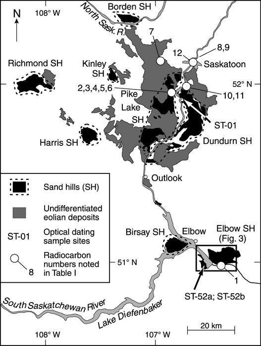
In this study, we present chronology and stratigraphy of eolian sediments along the South Saskatchewan River region of south-central Saskatchewan (Fig. 1), thus extending the spatial and temporal record of dune activity on the Canadian prairies. Optical ages documenting the timing of valley-infilling by sand dunes in the Qu’Appelle River area and cliff-top eolian deposition along the South Saskatchewan River, near Saskatoon, are reported. These ages are used in conjunction with published radiocarbon and optical ages to develop a chronology for eolian activity in south-central Saskatchewan and, more regionally, for the southern Canadian prairies.
Table I
Radiocarbon ages associated with eolian deposits in the Saskatoon area (compiled from McCallum and Wittenberg, 1968; Christiansen, 1970; Dyck, 1970; Turchenek et al., Walker, 1992; Morlan et al., 2001)

Radiocarbon ages uncorrected for δ13C values; the GSC age is reported with error of ±2σ, other ages are reported with error of ±1σ.
Calibrated ages shown with error of ±1σ; value in brackets represents the highest probability age intercept.
Radiocarbon age not used in present study. See text for details.
Setting
The study area is in south-central Saskatchewan, informally defined as that part of Saskatchewan between Regina and Saskatoon (Fig. 1). As with other glaciated regions of Canada east of the Rocky Mountains, the initiation of eolian activity post-dates the retreat of the Laurentide Ice Sheet and drainage of associated meltwaters. In Saskatchewan, the ice sheet retreated between about 20.0 and 9.0 cal ka BP, following the regional slope of the land surface from the southwest to the northeast. According to Christiansen (1979), the Saskatoon region was still covered by glacial ice about 14.5 cal ka BP, and was subsequently inundated by Glacial Lake Saskatoon until approximately 13 cal ka BP (Dyke et al., 2003). Deltaic sands and glaciolacustrine silts associated with the glacial lake were reworked by wind following postglacial incision of the South Saskatchewan River (Christiansen, 1970). Similarly, glacio-fluvial, -deltaic and -lacustrine sediments comprise source materials for most major dune fields in the study area (Christiansen, 1970; Scott, 1971; David, 1977), with the exception of a few dune areas derived from postglacial alluvial sediments or eroding cliffs along the South Saskatchewan River. These latter dunes are typically small and localized, however, as the sediment supply to them is low. Although presently residing entirely within the prairie ecozone, sand dunes within south-central Saskatchewan are typically vegetated by a mix of parkland and grassland vegetation.
Paleoclimatic proxy records from other parts of the Great Plains have shown an association between regional aridity and eolian activity, and regional moisture and paleosol development (Muhs and Holliday, 1995; Wolfe et al., 2000; Forman et al., 2001; Muhs and Zárate, 2001; Wolfe et al., 2001). Although few paleoclimatic proxy sites exist within the immediate vicinity of the study area, paleolimnological studies from within the prairie ecozone provide a broadscale view of Holocene climate change that may be applicable for most of the southern Canadian prairies. Immediate postglacial conditions are considered to have been cooler and moister than present, as indicated by fossil evidence of open spruce woodland on the Missouri Coteau, east of Regina, dating to about 12 cal ka BP (Yansa and Basinger, 1999), and high lake levels and freshwater conditions characterizing prairie lakes (Lemmen and Vance, 1999). An abrupt change from freshwater to saline conditions marks the transition to an arid climate in the late glacial and early Holocene (about 12 to 8 cal ka BP), followed by a period of peak aridity in the mid-Holocene (about 8 to 6 cal ka BP), as marked by saline and dry lakes in the prairie ecozone at these times (Lemmen and Vance, 1999). The mid-Holocene was evidently an interval of severe aridity across the southern Canadian prairies, with regional water-level reductions possibly as great as 6-15 m (Remenda and Birks, 1999) and a northward advance of the prairie ecozone (Vance et al., 1995).
Lake sediment records indicate rising groundwater tables on the southern Canadian prairies beginning about 5 cal ka BP, roughly co-incident with the onset of neoglaciation (Lemmen and Vance, 1999). However, this shift in climate was evidently time transgressive across the prairies, occurring earlier in Alberta (about 7-6 cal ka BP) than in Manitoba (about 4.5-3 cal ka BP) (Vance et al., 1995). Maximum water levels and freshwater conditions prevailed on the southern Canadian prairies about 3 to 2 cal ka BP. The latter half of the Holocene was characterized by a climate significantly more humid than that which existed during the preceding half. Nevertheless, limnological records from the southern Canadian prairies and the northern Great Plains of the United States suggest that even the last 1000 years have been interspersed by droughts that were more frequent and of greater magnitude than historic droughts (Lemmen and Vance, 1999; Fritz et al., 2000; Yu et al., 2002).
Field Sites
Elbow Sand Hills
The Elbow Sand Hills reside on the upper reaches of the Qu’Appelle Valley along the Gordon Mackenzie Arm of Lake Diefenbaker, about 15 km southeast of the town of Elbow (Fig. 2). They occur in the moist mixed grassland ecoregion of the prairie ecozone, and cover an area of approximately 182 km2. Sand dunes are found on either side of the Gordon Mackenzie Arm, with the main body of sand hills located on the east side. The primary source material for these dunes are glacio-lacustrine and outwash sediments deposited into Glacial Lake Birsay, which formed prior to Glacial Lake Saskatchewan and drained southeastward through the Qu’Appelle Channel (Scott, 1971). Most of the dunes are stabilized by vegetation, but some active dunes occur, including a large blowout and parabolic dune complex located in the northwestern portion of the dune field (Fig. 3).
Figure 2
Study area in south-central Saskatchewan, showing location of eolian deposits, optical dating sample sites, and radiocarbon ages noted in text.
Carte de la région à l’étude dans le centre-sud de la Saskatchewan, montrant la localisation des dépôts éoliens, des sites de datation optique et des âges au radiocarbone signalés dans le texte.
Only a small area of dunes is presently observed on the western side of the Gordon Mackenzie Arm, as most were flooded in 1967 following construction of the Gardner and Qu’Appelle dams and the creation of Lake Diefenbaker (Fig. 3a and b). Prior to flooding, it was evident that the Qu’Appelle Valley had been partially infilled by sand dunes (Fig. 3b). Following inundation, the western shoreline has eroded and exposed sand dune valley-infill deposits. Sample sites ST-52a and ST-52b were selected for optical dating on this western shoreline of Lake Diefenbaker in order to determine the timing of valley-infilling by these dunes.
Figure 3
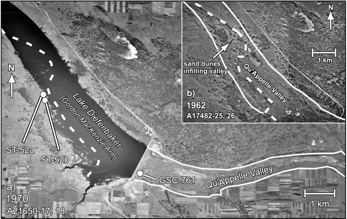
a) 1970 and b) 1962 airphotos of the Elbow Sand Hills, showing inundation of sand dunes in the Qu’Appelle River Valley by Lake Diefenbaker and location of optical dating sample sites.
Photographies aériennes de a) 1970 et de b) 1962 des Elbow Sand Hills montrant l’inondation des dunes de sable dans la vallée de la rivière Qu’Appelle par le lac Diefenbaker et la localisation des sites de datation optique.
Dundurn Sand Hills and Saskatoon Area
The surficial geology south of the Saskatoon region is dominated by eolian deposits, straddling alluvial deposits of the South Saskatchewan River valley. The two primary dune fields south of the Saskatoon area are the Dundurn and the Pike Lake Sand Hills (Fig. 2). The Dundurn Sand Hills lie east of the South Saskatchewan River. The source for these dunes are glacio-lacustrine and glacio-deltaic sediments that accumulated within Glacial Lake Saskatoon, about 14.5 cal ka BP (Christiansen, 1979). The greater part of the Dundurn area is covered by blowout hollows, windpits, and blowout dunes. Some elongate ridges also occur towards the south, a few of which have been historically active on their south-facing sides (David, 1977). The sand hills cover an area of approximately 312 km2. Sample site ST-01 is located in an exposure along the western edge of the Dundurn Sand Hills, on the east side of the South Saskatchewan River (Fig. 2). This site was selected to determine the timing of eolian activity of local cliff-top eolian deposits. These types of deposits have been shown to provide a good source of paleoenvironmental data elsewhere on the Great Plains that complement more commonly studied dune fields (Rawling et al., 2003)
The Pike Lake Sand Hills lie on the west side of the South Saskatchewan River, approximately 10 km southwest of Saskatoon (Fig. 2). The principal dune field covers an area of about 130 km2. The source sediments for these dunes are Glacial Lake Saskatoon deltaic deposits. Combined with the Dundurn Sand Hills on the east side of the river, this is the largest dune area in south-central Saskatchewan. The sand dunes in this area are presently vegetated and inactive, and only a few blowouts have occurred in areas that have been disturbed. No optical ages were obtained from this area as a comprehensive radiocarbon chronology has already been developed from paleosols in the eolian deposits (Morlan et al., 2001) (Table I and Fig. 2). The radiocarbon ages, together with the optical ages reported herein, are used to determine the timing of eolian activity in the Saskatoon area.
Methods
Nine samples were collected for optical dating. The samples were taken from shallow pits dug horizontally into natural exposures and stored in light-tight one-litre steel cans. The field and laboratory reference numbers, sample depths and locations are shown in Table II. The sedimentology and stratigraphy of each site was studied and described in order to establish the depositional environment.
Optical dating measures time elapsed since quartz or feldspar were last exposed to sunlight. General descriptions of available techniques are found in Wintle (1997), Aitken (1998), Huntley and Lian (1999), and Lian and Huntley (2001). For this study, sand sized (180 to 250 μm diameter) K-feldspar grains were dated by exciting them with near-infrared (1.4 eV, ~880 nm) photons and measuring the violet (3.1 eV, 400 nm) photons emitted in response. For each sample, the multiple-aliquot, additive-dose with thermal transfer correction method was used to determine the equivalent dose, and this, together with a measure of the environmental dose rate, and a correction for anomalous fading, was used to calculate the optical age. The optical ages are listed in Table II, whereas details of the procedure can be found in Lian et al. (this issue).
Samples of eolian sand and of paleosols developed in eolian sand were collected at discrete depths to quantify soil Munsell colour, grain size distribution, organic carbon and calcium content. Organic carbon content was determined on pulverized whole sample sediment splits using a LECO CR-412 carbon analyser, based on carbon released at combustion temperatures of 840 °C. Calcium content (% CaO) was determined by energy-dispersive X-ray fluorescence on pulverized (63-500 μm diameter) sediment splits.
Table II
Site locations, field and laboratory numbers, depth of collection, total dose rates (ḊT), equivalent doses (De), and optical ages. See Lian et al. (this volume) for details on optical age calculations

Depth below ground surface
Total dose rate, ḊT = dose rate due to α, β and γ radiation plus that due to cosmic rays.
Corrected for anomalous fading using the model of Huntley and Lamothe (2001).
The nature of the scatter in the normalized dose-response data suggest the presence of some unbleached grains, and hence the calculated age is a maximum value (Lian et al, this volume).
Age determinated using a natural sunlight bleach for the thermal transfer correction. For all other samples a red-infrared bleach was used (see Lian et al., this volume).
In addition to the samples collected for this study, the literature was reviewed for radiocarbon ages applicable to eolian deposits in south-central Saskatchewan. A number of paleosols, detrital organic and bone collagen samples have been dated in association with eolian deposits in the region. Fifteen ages pertaining to eolian deposits were found in the review, all of which are reported in Morlan et al. (2001) and in Table I. Ages obtained from organic matter in paleosols within eolian deposits primarily provide age estimates for soil development between periods of eolian activity. Other radiocarbon ages, derived from organic matter in paleosols occurring at the interface between eolian deposits and a substrate of non-eolian origin, provide maximum limiting ages on the timing of eolian deposition. Further details regarding these ages are found in McCallum and Wittenberg (1968), Dyck (1970), Christiansen (1970), Turchenek et al. (1974) and Walker (1992).
Results
Elbow Sand Hills
Erosion along the western side of the Mackenzie Arm of Lake Diefenbaker has formed a set of well-exposed sections in stabilized sand dunes along the shoreline. The two optical dating sample sites consisting of sections approximately 7 m high are located approximately 200 m apart. The inland terrain is generally chaotic, consisting of former blowout hollows and elongate ridges comprising the arms of stabilized parabolic dunes. Surfaces at both sites were well-vegetated with grasses and forbs and with thick, but patchy, woody vegetation (Populus tremuloides, Rosa woodsii, Juniperus horizontalis, Elaeagnus commutata and others) particularly within former blowout hollows, indicating present eolian stability.
At site ST-52a, the upper 3.5 m exposes a fine-grained, light olive brown (2.5Y 5/4) eolian sand with sub-parallel laminations, indicative of eolian ripple deposits. The remainder of the section was heavily sloughed, and was therefore not excavated. An optical age obtained from a depth of 2.5 m, indicates deposition of eolian sand 145 ± 20 years ago (Table II and Fig. 4).
At site ST-52b, the upper 3 m of the section was exposed by natural erosion, while the underlying 3 m was excavated, and an additional 1 m was sampled with a hand-auger. The section contained 6 m of fine-grained, well-sorted, olive brown to light olive brown (2.5Y 4/4 to 5/4) eolian sand, containing a set of eight dark greyish brown (10 YR 4/2) paleosols. Sedimentary structures were not visible within the freshly-dug eolian sands, however the upper naturally-exposed section at 1.7 m depth revealed sub-horizontal laminations indicative of ripple deposits. The paleosols contained weakly-developed Ah/C or Ah/AC/C profiles, with varying extents of bioturbation, similar to paleosols developed elsewhere in eolian sands on the prairies (Boyd, 2000; Muhs and Wolfe, 1999; Wolfe et al., 2000). Sand below a depth of 6 m showed evidence of strong oxidation/reduction, with colour changes from light olive brown (2.5Y 5/4) to greyish brown (2.5Y 5/2), and visible carbonate granules. Sediments were water-saturated below a depth of 7.2 m.
Figure 4
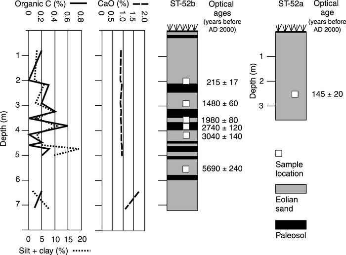
Section diagrams for sample sites in the Elbow Sand Hills, showing stratigraphy, optical ages, and organic carbon, silt/clay and calcium concentrations.
Diagrammes des coupes aux sites d’échantillonnage dans les Elbow Sand Hills, montrant la stratigraphie, les âges optiques et les concentrations en carbone organique, en argile/silt et en calcium.
Organic carbon and silt/clay content of the sediments vary similarly with depth in the top 5 m of the section (Fig. 4; note that sampling below 5 m was hampered by a loss of section). Organic carbon content typically increases from < 0.2 % in eolian sands to 0.3 to 0.6 % in the paleosols developed in the eolian sands. The silt and clay content within the eolian sands is typically < 5 %, but between 10 and 20 % within the paleosols. These trends suggest that the paleosols represent periods of surface stability, during which both organic material and fine-grained sediment (from organic and inorganic sources) accumulated.
In contrast, calcium content in both the eolian sands and paleosols is consistently < 1 % in the upper 5 m of the section, but increases slightly to between 1.2 and 1.7 % below 6 m depth, where carbonate granules also occur. Both eolian reworking and leaching through pedogenesis have been suggested as possible mechanisms for depleted carbonate contents in profiles elsewhere on the northern Great Plains (Muhs et al., 1997a; Hopkins and Running, 2000; Wolfe et al., 2000). It is probable that comparatively high calcium concentrations at depth at this site are a result of leaching of carbonates from the overlying sediments. Nevertheless, successive reworking of the overlying eolian deposits as well cannot be ruled out as an explanation for the uniformly low carbonate contents in these sediments.
Due to the high number of paleosols contained within the section, it was not practical to date all of the depositional events. Instead, six optical ages provide chronology of eolian activity and, consequently, timing of infilling of the Qu’Appelle Valley by eolian deposits (Table II and Fig. 4). The pattern of scatter in the dose-response data suggest that all of the samples consist of grains that have received sufficient sunlight exposure prior to burial (Lian et al., this volume). The lowermost sample, bracketing paleosols at depths of 5.1 and 5.9 m, indicates deposition of eolian sand at 5.69 ± 0.24 ka. Three overlying samples were collected around the most well-developed paleosol in the section (as indicated by organic carbon content and moist Munsell colour). These indicate eolian deposition at 3.04 ± 0.14 ka (4.2 m depth), paleosol development between about 2.74 ± 0.12 ka (3.9 m depth) and 1.98 ± 0.08 ka (3.5 m depth), and renewed eolian deposition at 1.98 ± 0.08 ka. A fifth sample, collected above the third paleosol, indicates that eolian deposition occurred at 1.48 ± 0.06 ka (2.9 m depth), while a sixth sample, collected above the second paleosol, indicates that eolian deposition occurred 215 ± 17 years ago (2.0 m depth).
Figure 5

Section diagrams for cliff-top dune deposits in the Dundurn Sand Hills, showing stratigraphy, optical ages, and organic carbon, silt/clay and calcium concentrations.
Diagrammes des coupes dans les dépôts dunaires au sommet des falaises dans les Dundurn Sand Hills, montrant la stratigraphie, les âges optiques et les concentrations en carbone organique, en argile/silt et en calcium.
In addition to the optical dating samples from Elbow Sand Hills, one radiocarbon sample (GSC-761), collected by R.W. Klassen from organic detritus beneath 3 m of eolian sand in the Qu’Appelle Valley (Figs. 2, 3 and Table I), yielded an age of 1460 ± 140 BP (about 1.3 cal ka BP). This age is comparable to the late Holocene optical ages obtained from site ST-52b.
Dundurn Sand Hills
The exposure at site ST-01 is located along the western edge of the Dundurn Sand Hills, on the east side of the South Saskatchewan River, and represents a cliff-top eolian deposit. The section, which is an excavated pit for sand extraction, is approximately 8 m high and 30-40 m long, exposing planar-bedded and cross-bedded, olive brown to light olive brown (2.5Y 4/4 to 5/4), eolian sands containing three distinct paleosols (Fig. 5). The lowermost paleosols occur at a depth of 5 and 6 m and reveal a set of Ah/C profiles. In some parts of the section, up to three paleosols are found at this level separated by eolian sand. In the main part of the section the paleosols converge and are nearly indistinguishable. The paleosols are underlain by a well-sorted medium-grade eolian sand. Although the structure in freshly-exposed sections of this lower unit appears massive, the eastern-most portion of the section reveals cross-bedded sands dipping eastward, indicative of slipface deposits of eolian bedforms.
Sands overlying these lower paleosols extend from 2 to 5 m depth and exhibit tabular cross-bedding (Fig. 5). The cross-bed sets dip eastward to southeastward, indicating dune-forming winds that were predominantly from the west. Above a depth of about 2 m, the stratigraphy changes to more finely- stratified sands with discontinuous bedding, indicative of vegetation-disrupted deposition. Another paleosol occurs at a depth of about 0.8 m and there is no recognisable soil profile at the surface. Thus, this paleosol may have represented the ground surface, prior to exposure of the section, that has since been buried by ongoing deposition of deflated sand.
The organic carbon content is low (0.1 to 0.3 %) both within the eolian sands and the lower paleosols although root tubules in the upper 4 m of the section show carbonate coatings. Sediments throughout the section are moderately-well to well sorted, fine-to-medium grade sand. However, the silt and clay content is variable, ranging from 4 % near the base of the section, to nearly 10 % at a depth of 4 m, and varying between 6 and 8 % above 4 m. There is also a slight trend of decreasing calcium content with depth to the lower paleosol, followed by an increase thereafter. The calcium content of the glaciofluvial source sediment samples collected in this area typically ranges from 3 to 3.5 %. By comparison, the sands at this location are slightly depleted in calcium.
The variability in calcium and silt/clay content may be explained by the close proximity of the deposit to the glaciofluvial source sediments that are locally exposed along the eastern rim of the Saskatchewan River valley, and by leaching of carbonates through pedogenesis. As this and other stabilized eolian deposits along the eastern rim of valley are cliff-top eolian deposits, calcium concentrations have not been greatly depleted by reworking, as the transport distance from the source materials is short. Thus, the decline in carbonate content and depletion within the lowermost paleosol may be due to leaching of carbonates, with translocation and accumulation at greater depths. The variability in the silt and clay content may be a function of the close proximity to the source sediments.
Samples from the exposed section were collected for optical dating. Cliff-top eolian deposits are not typically ideal for optical dating because of the short transport distance and the increased probability that sands may not receive adequate exposure to sunlight prior to deposition (Huntley and Lian, 1999). Indeed, the pattern observed in the scatter in the normalized dose-response data obtained from sample SFU-O-211, collected at a depth of 4 m, indicates the presence of some unbleached grains (see Lian et al., this volume, for a thorough discussion). As a result, the optical age calculated for this sample (< 2.76 ± 0.32 ka; Table II) must be considered a maximum age for this part of the deposit. The uninterrupted sequence of cross-bedded sediments from a depth of 2 to 5 m suggests that much of the deposit probably aggraded during this time. The lower sample from a depth of about 7 m is well-bleached and indicates an age of deposition of approximately 5.21 ± 0.22 ka. Thus, the age of the lower paleosols are of intermediate age, between 5.21 and about 2.76 ka.
Saskatoon Area
Of the radiocarbon ages reported in Table I, only three are considered inapplicable to this study due to probable contamination, stratigraphic uncertainty, or the type of material sampled. Sample S-440 is discounted due to probable coal contamination; sample S-2035 is discounted as overlying sediments are of mixed fluvial and eolian origin (Morlan et al., 2001); and sample S-403 is discounted as it is comprised of a composite of several bone collagen samples (Dyck, 1970) and it does not constitute a stratigraphic marker. It should also be noted that several radiocarbon ages from an occupation layer in a paleosol, reported by Walker (1992) from the Gowen Site near Saskatoon, may also be applicable to this study. Seven bone collagen and charcoal samples dating to between 5750 ± 140 BP (S-1527) and 6160 ± 160 BP (S-1971) provide maximum-limiting ages for overlying eolian sands, but were not included here due to the limited chronology for units lower in the section.
Of the 11 radiocarbon ages in the surrounding Saskatoon area, seven are late Holocene in age (about 4.1 to 0.7 cal ka BP), similar to the chronologies observed in the Elbow and Dundurn Sand Hills. Five of these paleosol ages (Nos. 2 to 7 in Table I) were derived from a single section in the Pike Lake Sand Hills, and indicate that successive periods of eolian activity and stability occurred within the last 3.8 cal ka BP. All of the other relevant radiocarbon ages from the Saskatoon area indicate early Holocene eolian activity. Three of these paleosols are developed within loess or loess-like material (Nos. 9, 11 and 12), dating to about 9.1, 11.3 and 10.2 cal ka BP (respectively) and one paleosol (No. 10) is developed within eolian sands dating to about 8.4 cal ka BP. This chronology is notable for the lack of ages corresponding to dune-forming events in the mid-Holocene.
Discussion
Eolian Chronologies
Figure 6 depicts chronologic summaries of eolian activity/stability in south-central Saskatchewan, utilizing the optical ages (Table II) and calibrated radiocarbon ages from paleosols (Table I). Summaries from eolian studies in other parts of the southern Canadian prairies are also shown, and are based on single and composite stratigraphic sections. Chronologies from southeast Alberta and southwest Saskatchewan are derived from composite sections in the Duchess and Great Sand Hills areas, as described by Wolfe et al. (2002b) and Wolfe et al. (2001), respectively. Chronologies from southwest Manitoba are derived from the Brookdale Road section in the Brandon Sand Hills (David, 1971; Wolfe et al., 2000, and this volume), and the Flintstone Hill Cutbank section in the Lauder Sand Hills (Boyd, 2000). A summary is also shown of the Holocene variability derived from multiple paleolimnological studies on the southern Canadian prairies (Lemmen and Vance, 1999), as reviewed in the introduction section of this paper.
Although the uncertainties in the ages in Figure 6 are not included, the analytical uncertainty in the optical ages is generally ±5 % of the reported age, and up to ±10 % (at 1σ) in only a few instances. Uncertainty in the calibrated radiocarbon ages is generally within ±4 % (at 1σ) for ages greater than 3.0 cal ka BP, and ±8 % for ages younger than this. Thus, the uncertainties in the two types of ages shown are comparable. Optical ages, by convention, are reported as “years ago” and in the case of this study as years prior to AD 2000, which is the year the samples were collected. By comparison, calibrated radiocarbon ages are reported as years prior to AD 1950. In this paper, we have not corrected for this difference.
South-central Saskatchewan
Paleosols within loess in the Saskatoon and Beaver Creek area record eolian activity in the early Holocene between 11.3 and 8.4 cal ka BP (Fig. 6). This period of eolian activity corresponds to the transition from deglacial to more arid conditions, and is most probably associated with localized drying and deflation of glaciolacustrine silts and deltaic sands under grassland vegetation cover. Eolian activity includes an initial period of loess deposition, as source sediments are sorted by the wind.
Within the study area there is presently no recorded eolian chronology between approximately 8.0 and 5.6 cal ka BP, corresponding to the time period leading up to and including the mid-Holocene Warm Period. The lack of an observed chronology from this interval might be explained by at least two possible causes. First, sand dunes might have been fully active during this period (or at least during a significant part of it), leading to nearly continual erosion and reworking of available sediment. As a result, little sedimentary record may exist in most locations from this time period, except for the latter phases of activity leading towards stabilization of the dune fields. Under this hypothesis, optical ages of 5.7 and 5.2 ka at Elbow and Dundurn, respectively, may reflect this latter phase of eolian activity. It should be noted, however, that at least one paleosol and eolian unit underlie the eolian sands dated at Elbow which could potentially record activity during the mid-Holocene.
Figure 6

Eolian chronology and Holocene climatic summaries for south-central Saskatchewan and the southern Canadian prairies from this study and other sources referred to in text.
Chronologie de l’activité éolienne et divisions climatiques de l’Holocène pour le centre-sud de la Saskatchewan et des Prairies, à partir de la présente étude et d’autres sources signalées dans le texte.
A second hypothesis is that eolian activity in the late Holocene has, itself, reworked most older eolian deposits. Indeed, it is evident that all sites in south-central Saskatchewan were active in the late Holocene. This includes dune field activity, cliff-top eolian deposition and valley-infilling by sand dunes. This period corresponds largely to the time of neoglaciation which is considered to have been generally cooler and moister than present (Lemmen and Vance, 1999). Nevertheless, it appears that there was sufficient variation between arid and humid intervals at this time, to result in successive periods of eolian activity. The preservation of late Holocene paleosols and eolian sands at Elbow and Pike Lake Sand Hills suggests, however, the eolian activity at this time did not necessarily rework most older deposits, but only partially reworked younger eolian sediments.
A final observation suggests that there was eolian activity during the very late Holocene in the Elbow Sand Hills. Optical ages from the two sites in this area indicate that the latest episodes of eolian activity occurred within the last 220 years. These ages suggest that either relatively recent drought, or some other disturbance effect, has resulted in dune reactivation in the southern part of the area that is not observed farther to the north.
The southern Canadian prairies
Using published optical and radiocarbon ages from other sites, in conjunction with the chronology just discussed, a regional eolian chronology for the southern Canadian prairies is presented. Beginning in southwestern Manitoba, the oldest eolian deposits in this area comprise a sand unit from the Flintstone Hill section in the Lauder Sand Hills (Figs. 1 and 6), which includes high-angle cross-beds indicative of dune deposits (Boyd, 2000). These deposits are underlain by fluvial and/or lacustrine sediments, pertaining to the drainage of the Glacial Lake Hind basin, dating to between 12.3 and 7.6 cal ka BP (Boyd, 2000). The eolian unit, bracketed by radiocarbon ages of 7.6 and 6.1 cal ka BP, represents the only eolian deposit on the southern Canadian prairies that dates to the time of the mid-Holocene Warm Period (Fig. 6). Boyd (2000) interpreted the period between 7.6 and 4.6 cal ka BP as being characterized by at least one eolian episode followed by wetter, and then subsequently drier, conditions as recorded by iron oxide and carbonate accumulations. As well, an erosional unconformity is observed in the section between 6.1 and 4.6 cal ka BP (Fig. 6). Between 4.6 and 3.5 cal ka BP, the area is interpreted as undergoing increased landscape stability, characterized by eolian sand sheet deposition and the development of several grassland (simple Ah-horizon) paleosols. A sequence of dune sands and paleosols, starting at about 3.5 cal ka BP, is indicative of successive activity and stability occurring in the late Holocene similar to that observed in south-central Saskatchewan.
Roughly 50 radiocarbon and optical ages on paleosols and eolian sediments have been obtained within the Brandon Sand Hills of southwestern Manitoba (Morlan et al., 2000; Wolfe et al., this issue). As observed in south-central Saskatchewan, none of these ages predate about 5.6 ka. A regional chronology for this area (Wolfe et al., 2000) indicates several discrete episodes of eolian activity and stability in the late Holocene that is well-characterized by the Brookdale Road Section (Fig. 6). An undated A/Btb/C soil profile, developed on the lowermost deltaic sands and gravels, probably documents late glacial or early Holocene soil development. However, paleosols occurring within overlying eolian sands contain minimally developed Ah/AC/C soils, indicating prairie grassland cover during the late Holocene.
These chronologic summaries in southwestern Manitoba indicate that the late Holocene was a time of intermittent eolian activity, during which underlying eolian deposits were not fully reworked. Instead, as in south-central Saskatchewan, successive eolian activity has partially reworked underlying sediments, resulting in an aggradation of eolian sediments and paleosols. The lack of a mid-Holocene eolian record may be best explained by intensive eolian activity at some point prior to about 5.6 ka.
Moving westward into the Great Sand Hills region of southwest Saskatchewan, of the nearly 40 optical and radiocarbon ages obtained from the area, nearly all pertain to the last 1000 years and most of these to the last 200 to 300 years (Fig. 6). This chronology suggests that droughts occurring within the last few hundred years have been significant enough to rework most earlier eolian deposits. In particular, drought in the late 1700s has been suggested by Wolfe et al. (2001) as forcing widespread dune activity in this area. Comparing this chronology to south-central Saskatchewan (Fig. 6), it appears that a similar drought event may have affected the Elbow Sand Hills area, though possibly to a lesser extent as the underlying late Holocene deposits are still preserved. However, the preservation of the underlying eolian deposits at Elbow could simply be a function of the location of the exposure, along a valley-side depositional basin. A similar record of very late Holocene eolian activity is also observed in the Duchess Sand Hills of southeastern Alberta (Wolfe et al., 2002b), where eolian activity has also occurred within the last 1000 years, and notably, within the last 260 years.
Conclusions
Eolian activity occurred in the Saskatoon area of south-central Saskatchewan between 11.3 and 8.4 cal ka BP, during a transition from deglacial to more arid conditions of the early Holocene. Although no eolian record presently exists elsewhere on the southern Canadian prairies for this period, it is probable that similar eolian activity occurred in most other areas of the region following deglaciation.
In the Lauder Sand Hills of southwestern Manitoba, dune activity is recorded between 7.6 and 6.1 cal ka BP, during the mid-Holocene Warm Period. At present, no other sites on the southern Canadian prairies record eolian deposition between approximately 8.0 and 5.6 cal ka BP. Rather than indicating a time of inactivity, it is inferred that significant dune activity occurred in most areas during at least portions of this period. Optical ages from eolian deposits from across the southern Canadian prairies, dating to between 5.7 and 4.6 ka (Fig. 6), may date the latter phases of this episode, prior to stabilization as indicated by paleosols dating to between 4.6 and 3.3 cal ka BP.
All areas of the southern Canadian prairies record phases of eolian activity and stability during the late Holocene. Thus, although this period may have been generally cooler than present, drought episodes may have reactivated dune areas several times in the last few millennia. Eolian activity at this time includes reactivation of dune fields, infilling of valleys and other basins, and cliff-top dune activity. Although cross-correlations of eolian chronology are still imprecise, regional paleosol development may have occurred between about 2.1 and 2.7 cal ka BP, and again after 1.4 cal ka BP.
Eolian activity has also occurred in most parts of the southern Canadian prairies in the last 1000 years during both the Medieval Warm Period and the Little Ice Age intervals. In southeastern Alberta and southwestern Saskatchewan, eolian deposits dating to this period dominate the chronology, suggesting that much of the landscape had been reworked during that time. Eolian deposits dating to within the last 300 years from this region, and the southern portion of south-central Saskatchewan, suggest that droughts occurring during the 1700s reactivated many of the dunes in this part of the southern Canadian prairies.
The existing chronology from the Great Sand Hills and the Duchess Sand Hills illustrates how dune activity can rework underlying eolian deposits, resulting in a loss of the earlier record. This example may be comparable to what occurred more regionally on the southern Canadian prairies during the mid-Holocene, as extensive dune activity resulted in reworking of older deposits, with no preserved record of this activity, the exception being the latter phases as the dunes trended towards stabilization.
Despite the present absence of chronology pertaining to the mid-Holocene, these records most likely are preserved in at least two distinct environments on the prairies. The first is in sand hills occurring in the boreal ecozone and in boreal outliers, where sand hills meet aspen parkland sub-regions of the prairie ecozone. Sites near the southern boreal forest margin and aspen parkland show strong evidence of vegetation change during the mid-Holocene, indicating that both grassland and parkland boundaries were northward of their present locations at this time (Vance et al., 1995). Thus, sand hills near Prince Albert, Edmonton and Red Deer (Fig. 1) may be candidates for providing direct evidence of re-activation at this time. The second environment in which mid-Holocene eolian deposits may be preserved is within depositional basins within the southern Canadian prairies. These are areas where sand dunes have migrated into, and partially or completely filled, dry river valleys and lake basins. The Qu’Appelle River Valley, prior to flooding by Lake Diefenbaker, is an example where sand dunes had migrated into a depositional basin. The preservation of the valley-infill deposits described in this paper illustrates the potential for the preservation of older deposits in this, and other basins. There are numerous examples on the southern Canadian prairies where sand dunes have migrated into small, dry creek or river valleys and lake basins, that could contain more complete records of eolian activity and stability during the Holocene.
Parties annexes
Acknowledgements
We thank staff at Douglas Provincial Park and Ron Watson for access to dunes at the Elbow and Dundurn sites, respectively. Assistance in the field by Janet Campbell and Zoe Pfeiffer, and in the laboratory by Sean Todd, was greatly appreciated. J. Elmo Rawling III, Scott St. George and Garry Running provided reviews and significant improvements to the manuscript. This research was supported by the Geological Survey of Canada, prairie drought and climate change impacts project, and by Natural Sciences and Engineering Research Council of Canada.
Notes
References
- Aitken, M.J., 1998. An Introduction to Optical Dating. Oxford University Press, Oxford, 267 p.
- Boyd, M., 2000. Changing physical and ecological landscapes in southwestern Manitoba in relation to Folsom (11,000-10,000 BP) and McKean (4,000-3,000 BP) site distributions, p. 21-38. In T.A. Radenbaugh and P. Douaud, eds., Changing Prairie Landscapes. Canadian Plains Research Center, University of Regina, 199 p.
- Christiansen, E.A., 1970. Geology, p. 3-17. In E.A. Christiansen, ed., Physical Environment of Saskatoon, Canada. Saskatchewan Research Council and National Research Council of Canada, Ottawa, CNRC Publication 11378, 68 p.
- _____ 1979. The Wisconsinan deglaciation of southern Saskatchewan and adjacent areas. Canadian Journal of Earth Sciences, 16: 913-938.
- Coote, D.R. and Padbury, G.A., 1987. Saskatchewan Preliminary Wind Erosion Risk Map. Land Resource Research Centre, Research Branch, Agriculture Canada, scale 1:1 000 000.
- David, P.P., 1971. The Brookdale Road section and its significance in the chronological studies of dune activities in the Brandon Sand Hills of Manitoba, p. 293-299. In A.C. Turnock, ed., Geoscience Studies in Manitoba. Geological Association of Canada, Ottawa, Special Paper 9, 352 p.
- _____ 1977. Sand Dune Occurrences of Canada: A Theme and Resource Inventory Study of Eolian Landforms of Canada. Department of Indian and Northern Affairs, National Parks Branch, Ottawa, Contract 74-230, 183 p.
- Dyck, I.G., 1970. Two Oxbow settlement types in central Saskatchewan. Na’pao, 2 (2): 1-29.
- Dyke, A.S., Moore, A.J. and Robertson, L., 2003. Preliminary Deglaciation Maps for North America. Geological Survey of Canada, Ottawa, Open File 1574, 32 maps, CD- ROM and 2 paper sheets.
- Forman, S.L., Goetz, A.F.H. and Yuhas, R.H., 1992. Large-scale stabilized dunes on the High Plains of Colorado: Understanding the landscape response to Holocene climates with aid of images from space. Geology, 20: 145-148.
- Forman, S.L., Oglesby, R. and Webb, R.S., 2001. Temporal and spatial patterns of Holocene dune activity on the Great Plains of North America: Megadroughts and climate links. Global and Planetary Change, 29: 1-29.
- Fritz, S.C., Ito, E., Yu, Z., Laird, K.R. and Engstrom, D.R., 2000. Hydrological variation in the northern Great Plains during the last two millennia. Quaternary Research, 53: 175-184.
- Hopkins, D.G. and Running IV, G.L., 2000. Soils, dunes and prairie vegetation: Lessons from the sandhills of North Dakota, p. 39-57. In T.A. Radenbaugh and P. Douaud, eds., Changing Prairie Landscapes. Canadian Plains Research Center, University of Regina, 199 p.
- Huntley, D.J. and Lamothe, M., 2001. Ubiquity of anomalous fading in K-feldspars, and the measurement and correction for it in optical dating. Canadian Journal of Earth Sciences, 38: 1093-1106.
- Huntley, D.J. and Lian, O.B., 1999. Using optical dating to determine when a sediment was last exposed to sunlight, p. 211-222. In D.S. Lemmen and R.E. Vance, eds., Holocene Climate and Environmental Change in the Palliser Triangle: A Geoscientific Context for Evaluating the Impacts of Climate Change on the Southern Canadian Prairies. Geological Survey of Canada, Ottawa, Bulletin 534, 295 p.
- Lemmen, D.S. and Vance, R.E., 1999. An overview of the Palliser Triangle Global Change Project, p. 7-22. In D.S. Lemmen and R.E. Vance, eds., Holocene Climate and Environmental Change in the Palliser Triangle: A Geoscientific Context for Evaluating the Impacts of Climate Change on the Southern Canadian Prairies. Geological Survey of Canada, Ottawa, Bulletin 534, 295 p.
- Lian, O.B. and Huntley, D.J., 2001. Luminescence dating, p. 261-282. In W.M. Last and J.P. Smol, eds., Tracking Environmental Change Using Lake Sediments. Volume 1: Basin Analysis, Coring, and Chronological Techniques. Kluwer, Dordrecht, 548 p.
- Lian, O.B., Huntley, D.J. and Wolfe, S.A., 2002. Optical dating of eolian dune sand from the Canadian prairies. Géographie physique et Quaternaire, 56: 191-202.
- Madole, R.F., 1994. Stratigraphic evidence of desertification in the west-central Great Plains within the past 1000 years. Geology, 22: 483-486.
- McCallum, K.J. and Wittenberg, R.T.D., 1968. University of Saskatchewan radiocarbon dates. Radiocarbon, 10: 365-378.
- Morlan, R.E., McNeely, R. and Nielsen, E., 2000. Manitoba Radiocarbon Dates. Manitoba Geological Survey, Winnipeg, Open File Report OF2000-1, 198 p.
- Morlan, R.E., McNeely, R., Wolfe, S.A. and Schreiner, B.T., 2001. Quaternary Dates and Vertebrate Faunas in Saskatchewan. Geological Survey of Canada, Ottawa, Open File 3888, 139 p.
- Muhs, D.R. and Holliday, V.T., 1995. Evidence of active dune sand on the Great Plains in the 19th century from accounts of early explorers. Quaternary Research, 43: 198-208.
- Muhs, D.R., Stafford, T.W., Jr., Been, J., Mahan, S., Burdett, J., Skipp, G. and Rowland, Z.M., 1997a. Holocene eolian activity in the Minot dune field, North Dakota. Canadian Journal of Earth Sciences, 34: 1442-1469.
- Muhs, D.R., Stafford, T.W., Jr., Swinehart, J.B., Cowherd, S.D., Mahan, S., Bush, C.A., Madole, R.F. and Maat, P.B., 1997b. Late Holocene eolian activity in the mineralogically mature Nebraska Sand Hills. Quaternary Research, 48: 162-176.
- Muhs, D.R. and Wolfe, S.A., 1999. Sand dunes of the northern Great Plains of Canada and the United States, p. 183-197. In D.S. Lemmen and R.E. Vance, eds., Holocene Climate and Environmental Change in the Palliser Triangle: A Geoscientific Context for Evaluating the Impacts of Climate Change on the Southern Canadian Prairies. Geological Survey of Canada, Ottawa, Bulletin 534, 295 p.
- Muhs, D.R. and Zárate, M., 2001. Late Quaternary eolian records of the Americas and their paleoclimatic significance, p. 183-215. In V. Markgraf, ed., Interhemispheric Climate Linkages. Academic Press, 488 p.
- Rawling, J. Elmo III, Fredlund, G.G. and Mahan, S., 2003. Aeolian cliff-top deposits and buried soils in the White River Badlands, South Dakota, USA. The Holocene, 13: 121-129.
- Remenda, V.H. and Birks, S.J., 1999. Groundwater in the Palliser Triangle: An overview of its vulnerability and potential to archive climate information, p. 57-66. In D.S. Lemmen and R.E. Vance, eds., Holocene Climate and Environmental Change in the Palliser Triangle: A Geoscientific Context for Evaluating the Impacts of Climate Change on the Southern Canadian Prairies. Geological Survey of Canada, Ottawa, Bulletin 534, 295 p.
- Scott, J.S., 1971. Surficial Geology of the Rosetown Map-Area, Saskatchewan (72O). Geological Survey of Canada, Ottawa, Bulletin 190, 40 p.
- Turchenek, L.W., St. Arnaud, R.J. and Christiansen, E.A., 1974. A study of paleosols in the Saskatoon area of Saskatchewan. Canadian Journal of Earth Sciences, 11: 905-915.
- Vance, R.E., Beaudoin, A.B. and Luckman, B.H., 1995. The paleoecological record of 6 ka BP climate in the Canadian prairie provinces. Géographie physique et Quaternaire, 49: 81-98.
- Walker, E.G., 1992. The Gowen Site: Cultural response to climatic warming on the Northern Great Plains (7500-5000 BP). Archeological Survey of Canada, Mercury Series Paper 145. Canadian Museum of Civilization, Hull, 208 p.
- Wintle, A.G., 1997. Luminescence dating: Laboratory procedures and protocols. Radiation Measurements, 27: 769-817.
- Wolfe, S.A., Huntley, D.J. and Ollerhead, J., 1995. Recent and late Holocene sand dune activity in southwestern Saskatchewan. Geological Survey of Canada, Ottawa, Current Research 1995-B: 131-140.
- Wolfe, S.A., Muhs, D.R., David, P.P. and McGeehin, J.P., 2000. Chronology and geochemistry of late Holocene eolian deposits in the Brandon Sand Hills, Manitoba, Canada. Quaternary International, 67: 61-74.
- Wolfe, S.A., Huntley, D.J., David, P.P., Ollerhead, J., Sauchyn, D.J. and MacDonald, G.M., 2001. Late 18th century drought-induced sand dune activity, Great Sand Hills, Saskatchewan. Canadian Journal of Earth Sciences, 38: 105-117.
- Wolfe, S.A., Huntley, D.J. and Ollerhead, J., 2002a. Optical dating of modern and late Holocene dune sands in the Brandon Sand Hills, southwestern Manitoba. Géographie physique et Quaternaire, 56: 203-214.
- Wolfe, S.A., Ollerhead, J., Huntley, D.J. and Campbell, C., 2002b. Late Holocene dune activity in the Duchess dune field, Alberta. Geological Survey of Canada, Ottawa, Current Research 2002-B3, 8 p.
- Yansa, C.H. and Basinger, J.F., 1999. A postglacial plant macrofossil record of vegetation and climate change in southern Saskatchewan, p. 139-172. In D.S. Lemmen and R.E. Vance, eds., Holocene Climate and Environmental Change in the Palliser Triangle: A Geoscientific Context for Evaluating the Impacts of Climate Change on the Southern Canadian Prairies. Geological Survey of Canada, Ottawa, Bulletin 534, 295 p.
- Yu, Z., Ito, E., Engstrom, D.R. and Fritz, S.C., 2002. A 2100-year trace-element and stable isotope record at decadal resolution from Rice Lake in the Northern Great Plains, USA. The Holocene, 12: 605-617.
 10.7202/009105ar
Liste des figures
Figure 1
Eolian deposits in the prairie ecozone, showing location of study area and other sand hills noted in text.
Carte de l’écozone des Prairies montrant la localisation de la région à l’étude ainsi que les autres collines de sable signalées dans le texte.
Figure 2
Study area in south-central Saskatchewan, showing location of eolian deposits, optical dating sample sites, and radiocarbon ages noted in text.
Carte de la région à l’étude dans le centre-sud de la Saskatchewan, montrant la localisation des dépôts éoliens, des sites de datation optique et des âges au radiocarbone signalés dans le texte.
Figure 3
a) 1970 and b) 1962 airphotos of the Elbow Sand Hills, showing inundation of sand dunes in the Qu’Appelle River Valley by Lake Diefenbaker and location of optical dating sample sites.
Photographies aériennes de a) 1970 et de b) 1962 des Elbow Sand Hills montrant l’inondation des dunes de sable dans la vallée de la rivière Qu’Appelle par le lac Diefenbaker et la localisation des sites de datation optique.
Figure 4
Section diagrams for sample sites in the Elbow Sand Hills, showing stratigraphy, optical ages, and organic carbon, silt/clay and calcium concentrations.
Diagrammes des coupes aux sites d’échantillonnage dans les Elbow Sand Hills, montrant la stratigraphie, les âges optiques et les concentrations en carbone organique, en argile/silt et en calcium.
Figure 5
Section diagrams for cliff-top dune deposits in the Dundurn Sand Hills, showing stratigraphy, optical ages, and organic carbon, silt/clay and calcium concentrations.
Diagrammes des coupes dans les dépôts dunaires au sommet des falaises dans les Dundurn Sand Hills, montrant la stratigraphie, les âges optiques et les concentrations en carbone organique, en argile/silt et en calcium.
Figure 6
Eolian chronology and Holocene climatic summaries for south-central Saskatchewan and the southern Canadian prairies from this study and other sources referred to in text.
Chronologie de l’activité éolienne et divisions climatiques de l’Holocène pour le centre-sud de la Saskatchewan et des Prairies, à partir de la présente étude et d’autres sources signalées dans le texte.
Liste des tableaux
Table I
Radiocarbon ages associated with eolian deposits in the Saskatoon area (compiled from McCallum and Wittenberg, 1968; Christiansen, 1970; Dyck, 1970; Turchenek et al., Walker, 1992; Morlan et al., 2001)
Radiocarbon ages uncorrected for δ13C values; the GSC age is reported with error of ±2σ, other ages are reported with error of ±1σ.
Calibrated ages shown with error of ±1σ; value in brackets represents the highest probability age intercept.
Radiocarbon age not used in present study. See text for details.
Table II
Site locations, field and laboratory numbers, depth of collection, total dose rates (ḊT), equivalent doses (De), and optical ages. See Lian et al. (this volume) for details on optical age calculations
Depth below ground surface
Total dose rate, ḊT = dose rate due to α, β and γ radiation plus that due to cosmic rays.
Corrected for anomalous fading using the model of Huntley and Lamothe (2001).
The nature of the scatter in the normalized dose-response data suggest the presence of some unbleached grains, and hence the calculated age is a maximum value (Lian et al, this volume).
Age determinated using a natural sunlight bleach for the thermal transfer correction. For all other samples a red-infrared bleach was used (see Lian et al., this volume).